
M 06
| M06 trunk road in Ukraine | |||||||||||||||||||||||||||||||||||||||||||||||||||||||||||||||||||||||||||||||||||||||||||||||||

|
|||||||||||||||||||||||||||||||||||||||||||||||||||||||||||||||||||||||||||||||||||||||||||||||||
| |
|||||||||||||||||||||||||||||||||||||||||||||||||||||||||||||||||||||||||||||||||||||||||||||||||
| map | |||||||||||||||||||||||||||||||||||||||||||||||||||||||||||||||||||||||||||||||||||||||||||||||||
 |
|||||||||||||||||||||||||||||||||||||||||||||||||||||||||||||||||||||||||||||||||||||||||||||||||
| Basic data | |||||||||||||||||||||||||||||||||||||||||||||||||||||||||||||||||||||||||||||||||||||||||||||||||
| Operator: | |||||||||||||||||||||||||||||||||||||||||||||||||||||||||||||||||||||||||||||||||||||||||||||||||
| Overall length: | 821.5 km | ||||||||||||||||||||||||||||||||||||||||||||||||||||||||||||||||||||||||||||||||||||||||||||||||
|
Oblasts : |
|||||||||||||||||||||||||||||||||||||||||||||||||||||||||||||||||||||||||||||||||||||||||||||||||
| Development condition: | partly 4-lane | ||||||||||||||||||||||||||||||||||||||||||||||||||||||||||||||||||||||||||||||||||||||||||||||||
 |
|||||||||||||||||||||||||||||||||||||||||||||||||||||||||||||||||||||||||||||||||||||||||||||||||
| The M 06 in the Carpathian Mountains | |||||||||||||||||||||||||||||||||||||||||||||||||||||||||||||||||||||||||||||||||||||||||||||||||
|
Course of the road
|
|||||||||||||||||||||||||||||||||||||||||||||||||||||||||||||||||||||||||||||||||||||||||||||||||
The M 06 is a Ukrainian trunk road . Starting from the Victory Prospectus in Kiev , it heads west via Zhytomyr , Rivne , Lemberg and Uzhhorod to Chop on the Hungarian border . Until 1991 it was part of the M 17 in the Soviet road system.
history
The route from Lemberg via Stryj to the then Austro-Hungarian border was in the territory of the Austrian crown land of Galicia until 1918 and was called the Stryjer Reichsstraße .
The sections between Lemberg and Brody or Lemberg and Stryj belonged to the territory of the Second Polish Republic between 1919 and 1939 and were declared state roads ( droga państwowa ) by the Polish Road Act of December 10, 1920 .
Between 2005 and 2008, the entire stretch between the Hungarian border via the Carpathian Mountains and Lviv was renovated.

The M06 in winter 2005

The M 06 between Kiev and Zhytomyr
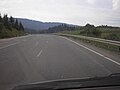
The M 06 in the Carpathian Mountains

The M06 in Lviv during the Euromaidan

Lviv city entrance during the Euromaidan


- ^ Announcement of the kk Finanz-Landes-Direktion in Lemberg of September 21, 1892 Zl. 69,797, regarding the tolling of the Aerarialstraßen in Galicia. LGBl. No. 73/1892, p. 181.
- ↑ Law of December 10, 1920 on the Construction and Maintenance of Public Roads in Poland. Dz.U. 1921 no. 6 poz. 32.
International: M 01 | M 02 | M 03 | M 04 | M 05 | M 06 | M 07 | M 08 | M 09 | M 10 | M 11 | M 12 | M 13 | M 14 | M 15 | M 16 | M 17 | M 18 | M 19 | M 20 | M 21 | M 22 | M 23 | M 24 | M 25 | M 26 | M 27 | M 28 | M 29
National: N 01 | N 02 | N 03 | N 05 | N 06 | N 07 | N 08 | N 09 | N 10 | N 11 | N 12 | N 13 | N 14 | N 15 | N 16 | N 17 | N 18 | N 19 | N 20 | N 21 | N 22 | N 23 | N 24 | N 25 | N 26 | N 27 | N 28 | N 30 | N 31 | N 32 | N 33