Mittelberg (Renon)

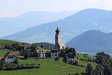
Mittelberg ( Italian Monte di Mezzo ) is a village located at 1120 m above sea level and belongs to the South Tyrolean municipality of Ritten . The village on the Ritten is delimited by the Finsterbachgraben to the west with its earth pyramids and the Köblbach to the east. Its location with the earth pyramids in the foreground and the South Tyrolean mountains in the background forms a well-known tourist backdrop on the Renon.
history
The location is first documented with the mention of a Carlus de Mittelperch in the register of the Bolzano notary Jakob Haas from 1242.
Worth seeing
Maria Saal ( 1185 m ) is a pilgrimage church from the 16th century and was enlarged in 1719. The furnishings match the style around 1700 and later. Originally, the miraculous image is said to have hung in a sheepfold and due to the increasing influx of people, a church is said to have been built later. In the church there is a mural of the Madonna with the umbrella.
The Nikolauskirche ( 1131 m ) with its red onion dome is a high medieval building, which probably dates back to the 12th century. In 1289 it is documented as "ad Mitelperch ... aput ecclesiam sancti Nicolai" . In the 14th century it was probably brought into its current form.
The earth pyramids in Finsterbach are one of the most popular sights on Renon.
Individual evidence
- ^ Ernst Steinicke: Geographical excursion guide: European region, Tyrol, South Tyrol, Trentino. Special excursions in South Tyrol. Institute for Geography, University of Innsbruck 2003. ISBN 978-3-901182358 , p. 228.
- ↑ Hans von Voltelini , Franz Huter (arrangement): Die Südtiroler Notariats-Imbreviaturen of the 13th Century. Part 2 (Acta Tirolensia 4). Innsbruck: Wagner 1951, pp. 20f., No. 38.
- ^ Hannes Obermair : Bozen Süd - Bolzano Nord. Written form and documentary tradition of the city of Bozen up to 1500 . tape 1 . City of Bozen, Bozen 2005, ISBN 88-901870-0-X , p. 111, no.77 .
Web links
Coordinates: 46 ° 33 ' N , 11 ° 29' E
