Modenhübel
| Modenhübel | ||
|---|---|---|
|
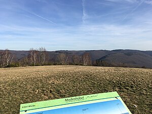
View from Modenhübel to the east |
||
| height | 485 m above sea level NHN | |
| location | North Rhine-Westphalia ( Germany ) | |
| Coordinates | 50 ° 34'25 " N , 6 ° 27'9" E | |
|
|
||
The Modenhübel is a 485 meter high elevation in Morsbach , a district of the town of Schleiden in the district of Euskirchen in North Rhine-Westphalia .
location
Morsbach is located northwest of the city center and can be reached via the federal highway 266 . From there, the Morsbach street of the same name branches off as a central connecting axis and runs in a northerly direction. It leads out of the village and ends around 500 meters further on a hill in a dead end. The way is signposted as Eifel-Blick . The second stage of the Eifel National Park Wilderness Trail leads past Modenhübel.
view
From the hill there is a broad view over the northern Eifel. It begins in the west via the former NS-Ordensburg Vogelsang , goes over the Kermeter as well as the Urft and the Schleiden district of Gemünd .
Web links
Individual evidence
- ↑ Modenhübel , website of the Nordeifel Nature Park, accessed on February 26, 2019.

