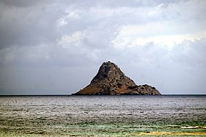
Modes (Poros)
| modes | ||
|---|---|---|
| View of Modi from the southwest | ||
| bodies of water | Saronic Gulf | |
| Geographical location | 37° 30′ 40″ N , 23° 31′ 56″ E | |
|
|
||
| length | 935 m | |
| broad | 240 m | |
| surface | 19 hectares | |
| highest elevation | 74 m | |
| resident | uninhabited | |
Modi ( Greek Μόδι ) is a Greek island about 1 km east of the island of Poros in the south of the Saronic Gulf . Administratively it belongs to the municipality of Poros in the Islands regional unit . Because of its shape, which is reminiscent of a lying lion, it is also called Liontari (Greek Λιοντάρι : "lion").
description
The rock island measures about 935 m from southwest to northeast, has a maximum width of about 240 m and has a base area of about 0.19 km². With a highest elevation of 74 m, the island was already an important landmark for shipping in ancient times.
story
During the Upper Palaeolithic , Modi was still connected to Poros and the mainland. However , it was separated from the two by sea level rise in the Mesolithic .
A first early Helladic settlement arose in the south of the island in the 3rd millennium BC. No structural remains of this have yet been uncovered. After a hiatus of about a millennium, in the 13th century B.C. A Mycenaean port settlement was built at the same place . After about 100 to 150 years, the settlement was destroyed in the 11th century BC. Destroyed by fire and abandoned. Only in the 4th century BC. a watchtower was erected, which existed until the Hellenistic period . Since then the island has been uninhabited.
finds
In Mycenaean times, slopes were terraced on the island. Stone structures were found on the terraces fortified with retaining walls. The Mycenaean settlement was surrounded by a fortification wall, remains of which have been discovered to the west. Also to the west, two poorly preserved rooms of a building were discovered. Shards of an Argive pictorial crater from the 12th century BC were found in two rooms of a building in the north of the settlement below the central rock elevation. ( SH III C) along with potsherds from SH III B/C. The burial of a newborn was found under the floor of one room . It was buried in a small wooden coffin with a decorative bone border. Also attached to the coffin was an appliqué carved from bone in the shape of an Egyptian djed pillar .
About 50 m to the south, a building with seven rooms was uncovered, the remains of which were covered with a layer of ash. SH III C ceramic shards were found in the destruction layer. It was mainly coarse and fine ware from SH III C early (1180-1130 BC) and SH III C middle (1130-1070 BC). A few sherds from SH III B2 (1250-1210) were also found BC) and SH III C Late (1070–1050 BC) A fragment of a copper ingot, a bronze sheet used to decorate a vessel, a bronze ax and two small bronze wheels (probably SH III C) give a clue significant trade contacts. A large stirrup jug and part of a tripod bowl are of Cretan origin and show that there were connections to this island.
Other surface finds included early Helladic potsherds and a serpentine button seal and a clay palette resembling early Cycladic marble palettes from the same period .
In 2003, the cargo of a 13th or 12th century BC Mycenaean shipwreck was discovered in a bay on the north-western side of the island . The hull of the ship, which was about 10 m long and could carry 25 tons of cargo, has not survived. At a depth of 25 to 38 m, mainly amphorae , pithamphorae and pithoi were found . It is the third Bronze Age wreck to be discovered in the Argosaronian Gulf , after the Cape Iria and Dokos wrecks . By 2010, over 30 transport vessels, potsherds and stone anchors had been lifted. The merchant ship probably transported mainly fruit and olive oil or wine.
To the north, the foundations of a late classical and Hellenistic watchtower have been found. Finds from Modi are exhibited in the Museum of Poros.
literature
- Christos Agouridis et al.: Palaeoenvironmental implications of a marine geoarchaeological survey conducted in the SW Argosaronic gulf, Greece. In: Journal of Archaeological Science: Reports Volume 12, 2016, doi:10.1016/j.jasrep.2016.08.004 .
- Eleni Konsolaki-Yannopoulou: Η πρωτοελλαδική κατοίκηση στο νησί του Πόρου (Σαρωνικός κόλπος). In: D. Katsonopoulou (ed.): Helike IV. Protohelladika. The Southern and Central Greek Mainland . Athens 2011, ISBN 9789608637726 , pp. 273–292.


