Mokelumne River
| Mokelumne River | ||
| Data | ||
| Water code | US : 228902 | |
| location | California (USA) | |
| River system | San Joaquin River | |
| Drain over | San Joaquin River → Suisun Bay | |
| origin | Confluence of the North and Middle Fork Mokelune Rivers in the Sierra Nevada 38 ° 22 ′ 20 ″ N , 120 ° 36 ′ 38 ″ W |
|
| muzzle |
San Joaquin River Coordinates: 38 ° 5 ′ 46 " N , 121 ° 34 ′ 12" W 38 ° 5 ′ 46 " N , 121 ° 34 ′ 12" W.
|
|
| Catchment area | 1712 km² | |
| Drain |
MQ |
18 m³ / s |
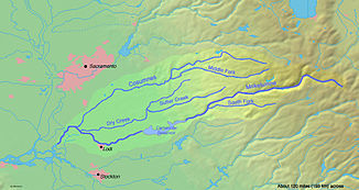
| Right tributaries | Dry Creek , Cosumnes River | |
| Reservoirs flowed through | Salt Springs Reservoir , Pardee Reservoir , Camanche Reservoir | |
| Medium-sized cities | Lodi | |
|
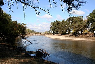
Lower Mokelumne River at Lodi |
||
The Mokelumne River is a river in California . The Upper Mokelumne River has its source in the Sierra Nevada and flows into the Camanche Reservoir in the area of the foothills of the Sierra. The Lower Mokelumne River is the lower section of the river below the Camanche Dam . It crosses the Central Valley with flow direction west, passes the city of Lodi and finally flows into the San Joaquin River in the area of the Sacramento-San Joaquin River Delta .
The name [ mɒˈkɛləmni ] is Plains Miwok and is composed of moke meaning " fishing net " and -umne , a suffix meaning "people of". The common English pronunciation - at least in the region - is [mə.ˈkɒ.lə.mi] . The town of Mokelumne Hill was named after the river around 1850.
Freetime activities
The Mokelumne River includes five well-known whitewater kayak stretches: Fantasy Falls, Devil's Nose, Tiger Creek Dam, Ponderosa and Electra-Middle Bar.
- Fantasy Falls , Class V +, 26-mile wilderness reach , runs from below Highway 4 in Alpine County to its confluence with Salt Springs Reservoir .
- Devil's Nose , Class IV-V, extends 17 miles from the Salt Springs Dam to the Tiger Creek Power Plant.
- Below the Tiger Creek Dam is the so-called Tiger Creek Dam Whitewater run , a scenic 3 mile long section of difficulty Class IV.
- The Ponderosa run leads from the Ponderosa Way to the Electra power plant.
- The westernmost whitewater section is the Electra-Middle Bar , a Class II-III whitewater stretch of over 5 miles. It starts below the Electra power plant and ends at the Middle Bar Bridge.
The Mokelumne River is ideal as a recreational area, for example for fishing, camping, picnicking, bird and nature watching and gold panning. Electra Road, east of Highway 49 , is popular with joggers and hikers. The large granite boulders, Calaveras Dome and Hammer Dome , near the Salt Springs Reservoir, are popular destinations for climbers. There are three campsites near Salt Springs: Mokelumne River, White Azalea, and Moore Creek. Above the Salt Springs Reservoir is the Mokelumne Wilderness .
nature and environment
The East Bay Municipal Utility District plans to enlarge the Pardee Reservoir, which would flood a large stretch of river, including the unique cultural and historical monuments on its banks. This would also jeopardize the Mokelumne River's designation as a National Wild and Scenic River .
See also
- Mokelumne River AVA
- Foothill Conservancy
- East Bay Municipal Utility District (EBMUD)
- Pardee Dam , Pardee Reservoir
- Camanche Dam , Camanche Reservoir , Mokelumne River Fish Hatchery
Web links
- Mokelumne River in the United States Geological Survey's Geographic Names Information System
- Wild & Scenic Mokelumne Update Foothill Conservancy, accessed September 28, 2018.
- Water supply East Bay Municipal Utility District, accessed September 28, 2018.

