
Molunate
| Molunate | |||
|
|||
| Basic data | |||
|---|---|---|---|
| State : |
|
||
| County : |
|
||
| Height : | 0 m. i. J. | ||
| Residents : | 217 (2001) | ||
| Telephone code : | (+385) 020 | ||
| Postal code : | 20 218 | ||
| License plate : | YOU | ||
| Boat registration : | CT | ||
| Structure and administration | |||
| Community type : | local community | ||

Molunat ( Italian. Molonta , from Greek. Μόλος / μῶλος "port" or illyr. Origin) with 217 inhabitants (2001) is the southernmost coastal town of Croatia .
Location and history
It is located in the historical region of Dalmatia, 38 km south of Dubrovnik . In the municipality of Konavle , to which it belongs, it is the only place by the sea besides Cavtat . From the agriculturally significant Konavosko polje basin , it separates the Konavoske stijene coastal mountain range, which slopes steeply towards the sea . The place is at the point where a peninsula juts out into the sea like a hammer and, together with the island of Veliki Školj , shields two large harbor bays off the coast: Luka Donji Molunat ( Molonta Grande ) to the northwest and Luka Gornji Molunat ( Molonta Piccola ). In the flat Luka Donji Molunat there is also the rocky island Mali Školj or Supetrić .
Molunat was already settled in ancient times. After the Konavle was acquired by the Republic of Ragusa in the 15th century , the protected stretch of coast was settled with families from the surrounding villages, who received parcels of land.
The eponymous district, flanked by the Hill Council , to which the original main road connection led from the former rural sub-center Pločice , is located on Luka Gornji Molunat , where there are sandy and pebble beaches.
On the “stem” of the peninsula is the district of Metale with a fishing port in Uvala Podmetale , part of the Luka Donji Molunat ; from here the road connection to the inland starts at present.
Both districts have grown together during the development of the place from a fishing village to a seaside resort with apartment houses and hotels as well as campsites , and the structural expansion is still ongoing. The small church of Sv. Nikola with a cemetery by the sea.
The place is located in a nature reserve and, in contrast to the dry peaks of the coastal mountains, has rich vegetation; these are particularly characteristic of cypresses and oleanders . The two bays are a popular diving area .
The wooded, approximately 1,300 m long “head” of the peninsula, parallel to the coast, rises to the two peaks Lastavica (140 m) and Kaštijo (99 m). The former is still used militarily. On the sea side, the peninsula ends in high cliffs between the north-western cape Rt Lokvice and the Vratlo strait , which separates it from the island of Veliki Školj . Between 1468 and 1471 the Ragusans provided it with a defensive wall at the narrowest point between the two bays , large parts of which are still preserved today. Also in the Metale district , directly in front of the defensive wall and opening to the southeast to Luka Gornji Molunat , the remains of a Roman theater were found in the 1960s; Because of the military use of the site at that time, some of the excavations were overbuilt and the rest of them went wild.
There are also prehistoric burial mounds in the municipality.
photos

View of Molunat

Church of Sv. Nikola

Molunat Bay

Molunat Bay

Slipway

Main street in February
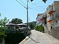
Main street in summer
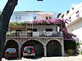
pension


