Mont Chaberton
| Mont Chaberton | ||
|---|---|---|
| height | 3136 m | |
| location | Department Hautes-Alpes , France | |
| Mountains | Cottian Alps | |
| Coordinates | 44 ° 57 '53 " N , 6 ° 45' 10" E | |
|
|
||
|
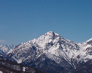
Mont Chaberton in winter - view from the Italian Susa valley |
||
The Mont Chaberton is a 3136 m high peak in the Cottian Alps on the border of France and Italy in the Hautes-Alpes department . At the summit, the ruins of a former Italian fort are still preserved, the eight brick turrets of which look like a crown from the Susa valley . Until the end of the Second World War , the mountain top with the fort belonged to Italy, but was ceded to France in the Paris Peace Treaty in 1947 .
From the Italian Susa Valley, Mont Chaberton can be reached via the increasingly decaying military road to the fort, which starts in Fenils (1276 m) and has 72 hairpin bends over a length of 14 km. In the upper section, especially shortly before the Colle del Chaberton (2671 m), it consists at best of a narrow footpath.
Fort Chaberton was built from 1891 and included a barracks 13 × 18 m and eight brick artillery towers. Each turret was equipped with a cannone da 149/35 A cannon . The French built an armored observation tower and two field observation posts to monitor Fort Chaberton during the fighting on the Italian front in 1940. Four field positions each for a Mortier de 280 modèle 14/16 type rapid fire mortar were then built outside the field of vision of the Italians, two on the Poët Moran and two on the Ayrette. They were under the command of Lieutenant Miguet. On the afternoon of June 21, 1940, the four mortars opened fire against the Italian fort. The first shot was too short, but the second already destroyed the cable car up the mountain and everyone else reached their destination. The Italians tried to return fire, but their turrets were quickly damaged and soon incapacitated.
A famous place on the military track is the Split Rock ( Roccia tagliata ) at an altitude of 2370 meters, where the road is blasted through a wild rock. Here, due to erosion, the width of the path narrows at a lofty height to only approx. One meter in places and the remainder of the road was patched up with steel rods and boards.
Until around 2003, the Chaberton was the highest point in the Alps that motor vehicles could approach (gravel road) and enjoyed a legendary reputation among off-road drivers. Since the route has not been maintained for years, the condition has deteriorated a lot. Due to landslides at an altitude of 1960 meters, progress, even with light off-road motorcycles, is only possible with great effort. Driving on with motor vehicles is now prohibited. The summit can be easily reached on foot.
In 2006 the lower part of the former military road ascending from Italy was repaired again, including the above-mentioned slope slide at 1960 meters.
The summit is a shorter way from the Italian Claviere (1760 m). Shortly before the border with Italy, a path leads to the Colle del Chaberton , from which the former military road leads in several hairpin bends to the summit.


