
Monte Aguila
| Mount Águila | ||
|---|---|---|
|
Coordinates: 37 ° 5 ′ S , 72 ° 26 ′ W Monte Águila on the map of Chile
|
||
| Basic data | ||
| Country | Chile | |
| region | Región del Bío-Bío | |
| City foundation | 19th century | |
| Detailed data | ||
| Population density | 6547 inhabitants / km 2 | |
| prefix | +56 43 | |
| Time zone | UTC −4 | |
| City Presidency | Mario Gierke Quevedo (Mayor of Cabrero) | |
| Website | ||
 |
||

Monte Aguila is a district of the municipality of Cabrero in the Región del Bío-Bío in Chile . Monte Aguila was the terminus of the abandoned railway line Monte Águila - Polcura. Monte Aguila has 6,574 inhabitants.
Toponymy
The name Monte Aguila is translated into German as the mountain of eagles . According to reports from the indigenous peoples who lived there in the first half of the 20th century, the name Monte Águila comes from the lonco Ñancomawida, whose name in mapudungún , the language of the Mapuche , means mountain of eagles .
history
Until the 19th century
The area around the present-day Monte Aguila was first of the ethnic groups of Mapuches and Araukanos populated. The first inhabitants were Mapuches, who lived in this arid and sparsely populated area with little vegetation. The ethnic group was known as Coyunches ("People of the Sands", "Gente de los Arenales").
In 1852 these indigenous people were forced to leave their land. The legal basis was a decree of the then President Manuel Bulnes Prieto . During his tenure from 1841 to 1851 he promoted the foreign colonization of the Mapuches' lands by settling German, Italian and French settlers on Indian land. As a result, there were several Mapuches uprisings with the aim of regaining their territories.
20./21. century
After the Saltpeter War (1880) the village was used for the transfer and dispatch of armaments. Recruits were also transported to their destinations in wagons. As early as 1887, a railway line was built between Monte Águila and the Argentine city of Neuquén , which contributed to the city's great economic and social boom. An important milestone in the consolidation of Monte Águila as a city was the construction of the Ramal , which connected the city with the Argentine city of Polcura . The Transand Railway , which started in 1905 and connects Chile and Argentina, and which was financed by the Chilean Porfirio Ahumada and his partners, the Argentines Carlos Viel, Martin Worman and Horacio del Río, also contributed to the economic boom of the city.
gallery

Entrance to the main square.

Fire Department.

Catholic chapel " Nuestra Señora del Carmen ".
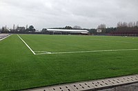
Monte Águila football stadium.

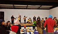
Parade of the " Chilean Aborigines ".
Gym.

Type " Copa de Agua " (water glass), with which the trains were supplied

Monte Águila sports complex in September.
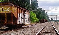
Unused railway machines in the city train station.
.jpg)


.jpg)
.jpg)

.jpg)

Web links
Individual evidence
- ↑ Demography of Cabrero ( Memento of the original from July 28, 2013 in the Internet Archive ) Info: The archive link was inserted automatically and has not yet been checked. Please check the original and archive link according to the instructions and then remove this notice. Official website of the municipality of Cabrero. Retrieved September 8, 2017 (Spanish)
- ↑ UBICACIÓN - Monte Aguila - CHILE Official website of Monte Aguila, location of the town. Retrieved September 8, 2017
- ↑ Censos de poblacion y vivienda population development on the website of the Instituto Nacional de Estadisticas. Retrieved September 8, 2017 (Spanish)
- ↑ Raul Torres Caces: Historia de Monte Águila . 2014.
- ↑ HISTORIA de Monte Aguila, Chile ::::. Retrieved September 3, 2017 .
- ↑ Historia breve di Monte Aguila , accessed on October 18, 2017.