Monte Caseros
| Basic data | ||
|---|---|---|
| Surface: | 2287 km 2 | |
| location | 30 ° 15 ′ S , 57 ° 38 ′ W | |
| Height above d. M .: | 70 m | |
| Population (2010): | 36,338 | |
| Density: | 16 inhabitants / km² | |
|
|
||
| administration | ||
| Province : |
|
|
| Department : | Monte Caseros | |
| Mayor: | Eduardo Leonel Galantini, PJ | |
| Others | ||
| Postal code : | W3220 | |
| Telephone code: | 03775 | |
| Monte Caseros website | ||
| map | ||

|
||
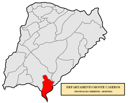
Monte Caseros is the capital of the department of the same name Monte Caseros in the province of Corrientes in northeast Argentina . In the classification of communes in the province of Corrientes, the city is in the 1st category.
The city is on the west bank of the Uruguay River across from Bella Unión in Uruguay . 36,338 inhabitants live in the place on an area of 2,287 km².
history
Monte Caseros was founded on October 5, 1829 on the banks of the Uruguay River at the Fig ford (Paso de los Higos). The then governor of Corrientes, Juan Gregorio Pujol , ordered the site to be assigned to Monte Caseros in memory of the Battle of Caseros , which was fought on February 3, 1852 northwest of what is now Buenos Aires and which led to the overthrow of the dictator Juan Manuel de Rosas call. The establishment of the Department of Monte Caseros was created by dividing the Department of Curuzú Cuatiá .
supporting documents
- ↑ mininterior.gov.ar: Situación Social ( MS Excel ; 198 kB) , accessed on April 27, 2012
- ↑ mininterior.gov.ar: Datos Generales ( MS Excel ; 95 kB) , accessed on April 27, 2012
