Monte Lema
| Monte Lema | ||
|---|---|---|
|
from the Val Veddasca |
||
| height | 1619 m above sea level M. | |
| location | Canton Ticino , Switzerland / Province Varese , Italy | |
| Mountains | Varese pre-Alps | |
| Dominance | 0.95 km → Piano del Poncione | |
| Notch height | 137 m ↓ Forcola d'Arasio | |
| Coordinates , ( CH ) | 46 ° 2 '26 " N , 8 ° 49' 58" O ( 707 916 / 99736 ) | |
|
|
||
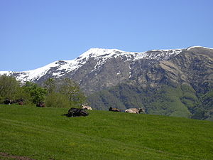
The Monte Lema is a mountain ( 1619 m above sea level ) in the Tambogruppe on the border between Lombardy ( Italy ) and the canton of Ticino ( Switzerland ) above the places Miglieglia and Astano . A cable car leads from Miglieglia to the summit.
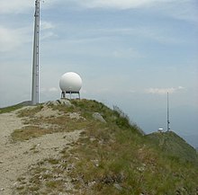
In addition to the mountain station, a mountain restaurant, an observatory and (since 2011) a weather radar station from MeteoSwiss can be found in the summit region .
From the summit you have a comprehensive panoramic view of the surrounding mountains of southern Ticino, of Lake Lugano and Lake Maggiore . The mountain region is accessible to hikers through a marked network of 80 kilometers of trails.
The summit region is also frequented by paragliders , mountain bike riders and model pilots.
Individual evidence
- ↑ MeteoSchweiz media releases - New weather radar on Monte Lema is operational, June 1, 2011 ( page no longer available , search in web archives ) Info: The link was automatically marked as defective. Please check the link according to the instructions and then remove this notice.


