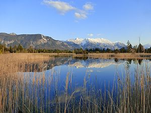
Moosbergsee
| Moosbergsee | ||
|---|---|---|

|
||
| Moosbergsee | ||
| Geographical location | Murnau Moor / Municipality Murnau , Garmisch-Partenkirchen , Bavaria , Germany | |
| Tributaries | (nameless trenches) | |
| Drain | Trenches to the Rechtach | |
| Location close to the shore | Ohlstadt | |
| Data | ||
| Coordinates | 47 ° 38 '41.7 " N , 11 ° 11' 18.6" E | |
|
|
||
| Altitude above sea level | 621 m | |
| length | 70 m | |
| width | 50 m | |
| Maximum depth | 4 m | |
The Moosbergsee is a moor lake in the Murnauer Moos , which is part of the Murnauer Moos nature reserve . It is fed superficially via smaller trenches and drained via a trench in the direction of Rechtach . There is a temporary ban on entry.
Other small lakes in the Murnauer Moos are Langer-Köchel-See , Schwarzsee , Krebssee , Neuer Moosbergsee , Haarsee and Rollischsee .
