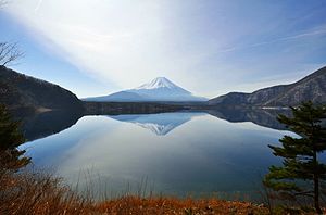
Motosu lake
| Motosu lake | ||
|---|---|---|

|
||
| Aerial view of the lake, 1975 | ||
| Geographical location | Yamanashi Prefecture , Japan | |
| Drain | underground to Shōji Lake and Saiko | |
| Places on the shore | Fujikawaguchiko , Minobu | |
| Data | ||
| Coordinates | 35 ° 27 '51 " N , 138 ° 35' 12" E | |
|
|
||
| Altitude above sea level | 900 m TP | |
| surface | 4.7 km² | |
| scope | 11 km | |
| Maximum depth | 121.6 m | |
| Middle deep | 67.3 m | |

|
||
| View over the lake towards Fujisan | ||
The Motosu Lake ( Jap. 本栖湖 , Motosu-ko ) is one of the Fuji Five Lakes near Mount Fuji in Japan .
It is part of the Fuji-Hakone-Izu National Park . The west bank of the lake has belonged to the city of Minobu (Minobuchō) since 2004 , the east bank has been part of the city of Fuji Kawaguchi Lake ( Fujikawaguchikomachi , until 2003 only city of Kawaguchisee / Kawaguchikomachi ) since 2006 ; he went to the village of Ober-Kuishiki ( Kamikuishikimura ; before 1889 Kuishiki).
Web links
Commons : Motosu Lake - Collection of Images, Videos and Audio Files
Individual evidence
- ↑ 調査 実 施 湖沼 一 覧 . Kokudo Chiriin , July 1, 2016, accessed July 25, 2016 (Japanese).
- ↑ a b 日本 の 主 な 湖沼 . (No longer available online.) MLIT , 2002, archived from the original on September 12, 2013 ; Retrieved September 15, 2013 (Japanese). Info: The archive link was inserted automatically and has not yet been checked. Please check the original and archive link according to the instructions and then remove this notice.
- ↑ Kokudo Chiriin : 平 成 29 年 全国 都 道 府 県 市区 町 村 別 面積 調 , 19 山 梨 県 , accessed on November 23, 2018.
