
Lake Kawaguchi
| Lake Kawaguchi | ||
|---|---|---|

|
||
| Aerial view of the lake, 1975 | ||
| Geographical location | Yamanashi Prefecture , Japan | |
| Tributaries | including from Saiko | |
| Drain | → Miyagawa → Sagami | |
| Islands | Unoshima | |
| Data | ||
| Coordinates | 35 ° 30 '54 " N , 138 ° 45' 24" E | |
|
||
| Altitude above sea level | 831 m TP | |
| surface | 5.48 km² | |
| scope | 18 km | |
| Maximum depth | 14.6 m | |
|
particularities |
UNESCO World Heritage Site |
|

Lake Kawaguchi ( Japanese 河口湖 Kawaguchi-ko ) is one of the Five Fuji Lakes near Mount Fuji in Japan .
It is located near Fujikawaguchiko in Yamanashi Prefecture and is - in terms of the number of tourists - the most famous of the Five Fuji Lakes . It is part of the Fuji-Hakone-Izu National Park . Since June 22, 2013 it has been part of the Fuji World Heritage Site .
During the climbing season (July and August), Kawaguchiko also serves as an important stopover for climbing Mount Fuji. It lies at an altitude of 831 m, which leads to relatively cool summers and often freezing winters.
Kawaguchiko has overtaken nearby Yamanaka Lake as the most popular region in the area in recent years .
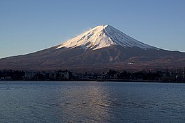
Mount Fuji and Lake Kawaguchi

Mount Fuji and Kawaguchiko Station

Lake Kawaguchi from the Kachikachi Mountains


Web links
- Entry on the UNESCO World Heritage Center website ( English and French ).
- Kawaguchiko homepage
- Climate information
Individual evidence
- ↑ 調査 実 施 湖沼 一 覧 . Kokudo Chiriin , July 1, 2016, accessed July 25, 2016 (Japanese).
- ↑ a b 日本 の 主 な 湖沼 . (No longer available online.) MLIT , 2002, archived from the original on September 12, 2013 ; Retrieved September 15, 2013 (Japanese). Info: The archive link was inserted automatically and has not yet been checked. Please check the original and archive link according to the instructions and then remove this notice.
- ↑ Fujisan, sacred place and source of artistic inspiration: Maps. In: World Heritage. UNESCO, accessed July 4, 2013 .