
Mount Boising
| Mount Boising | ||
|---|---|---|
| height | 4150 m | |
| location | Papua New Guinea , Madang Province | |
| Dominance | 148 km → Mount Wilhelm | |
| Notch height | 3709 m | |
| Coordinates | 5 ° 57 '15 " S , 146 ° 22' 30" E | |
|
||

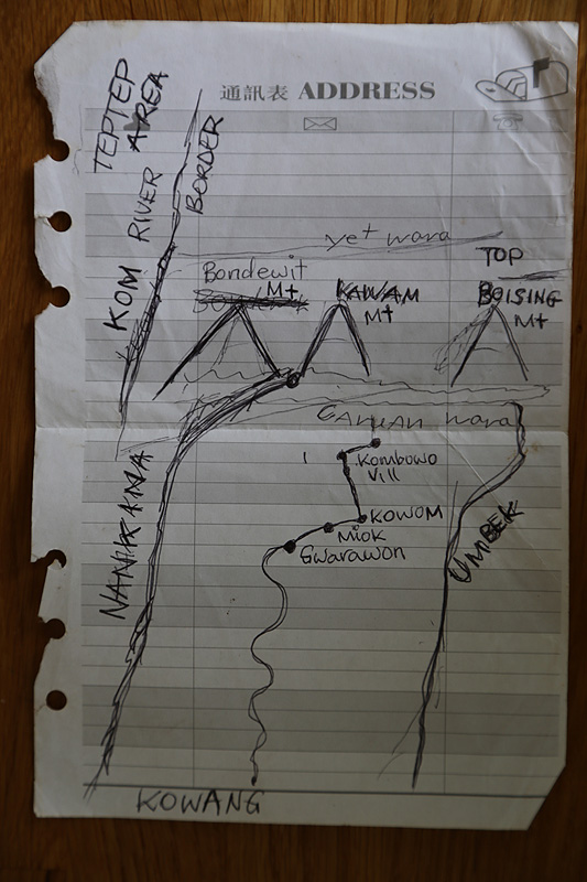
Mount Boising ( eng . Mountain stops the fight ) is the local name of the highest mountain in the Finisterre Mountains in New Guinea . Other possible names are Mount Gladstone and Mount Finisterre .
With a height of 4150, 4175 or 4120 m, it is the third highest and most prominent mountain in Papua New Guinea . With a notch height of 3709, 3670 or 3734 m, it is also behind the Puncak Jaya , Mauna Kea and Mount Cook, the mountain with the fourth highest notch height in Australia and Oceania (the second highest in any Australian country) and number 41 worldwide. Until 2014 it was also the most prominent (officially) unclimbed mountain. The official first ascent took place on June 25, 2014 by Petter E. Bjørstad, Pål Jørgen Bjørstad, Wionare Mitimu, Nathan Hone and Roinu Roipo. Bjørstad failed once in 2012.
The mountain is located in Madang Province , 4.4 km north of the border with Morobe Province , in northeast New Guinea. In the north it is 36.5 km to the Bismarcksee , 70 km in the east the Huon Peninsula begins . The region is heavily forested, but the summit and its surroundings are above the tree line and are only covered with grass. Nearby villages are Teptep 20 km east, Yaut 26 and Monara 31 km northeast, and Sarakiri 32 km northwest; as well as Sapsap , Ganzewit , Kwombwu and Gwarawon in the immediate vicinity. There are no roads within a 30 km radius of the mountain. The next slightly larger town on the coast is Saidor , 38 km north-northeast.
Individual evidence
- ↑ This name is used by OpenStreetMap .
- ↑ a b c Mount Boising , report of a summit ascent 2014, with photos, quote: "One of the three heads of the" Clans "that are" Landowners "of this mountain, drew small map by hand where this name (Mount Boising) appeared . The other two "landowner" clans are in full agreement. It became clear from my visit over 2 weeks that this name is "widely" used and accepted to mean this peak among about a local population of perhaps 2000 people. “ Since the mountain has no official name, this local name of Nankina - language used.
- ↑ It is not certain whether the name actually refers to this mountain. Hugo Zöller named the highest peak in the Finisterre Mountains that way on his journey in 1888 . The name appears on this US military map from 1942, but at an altitude of only 3475 m. It is not unlikely that another mountain is meant
- ↑ a b The World's Top 100 Summits ; Eberhard Jurgalski , David Metzler, Parys Lisiecki, Aaron Maizlish, Jonathan de Ferranti on: peaklist.org , March 22, 2008. (Excel file, 63 kB)
- ↑ a b Mount Boising, Papua New Guinea , Peakbagger.com
- ↑ topographic map (Saidor), 1: 100,000, based on aerial photographs from 1973-74 (link currently not available)
- ^ A b Ultra- Celebrity Summit in Papua New Guinea , Aaron Maizlish 2004; peaklist.org
- ↑ Data from the Shuttle Radar Topography Mission , 2000
- ↑ The route information comes from Google Maps .