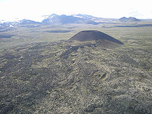
Mount Edziza
| Mount Edziza | ||
|---|---|---|
|
Mount Edziza |
||
| height | 2793 m | |
| location | British Columbia ( Canada ) | |
| Mountains | Spectrum Range Melt | |
| Coordinates | 57 ° 43 ′ 0 ″ N , 130 ° 38 ′ 0 ″ W | |
|
|
||
| Type | Stratovolcano | |
| Normal way | Hiking route | |
The Mount Edziza is a 2793 m high volcano in the northwest of the Canadian province of British Columbia and is part of the Boundary Ranges , as part of the Coast Mountains . It consists of a thin basalt layer with a central dome made of andesite , dacite and rhyolite . The Mount Edziza Provincial Park, which is 2661.80 km² in size and is also located in Canada's second largest volcanic complex, the Mount Edziza volcanic complex, was built around the mountain .
The volcanic area is about 7.5 million years old, the second phase of the activity was about 3.5 million years ago, the third about 1.6 million years. Mount Edziza was not created until the fourth phase around a million years ago. The fifth and so far last phase of activity began around 10,000 years ago and ended around AD 700.
It has been a dormant volcano since the last eruption, but there have been some minor eruptions around it, so that there are now more than 30 conical elevations around the volcano. Examples of this are the perfectly symmetrical volcanic cone Eve Cone , as well as the volcanic cones Coffee and Cocoa . Some hot springs on the western flank are also showing activity, as are seismic measurements.
In addition, the volcano harbors archaeological sites that trade in obsidian over great distances as early as around 8000 BC. Prove.
history
Obsidian mining in British Columbia reaches at least 8000 BC. BC and was based on the deposit at Edziza, the core area of which is about 1800 to 1900 m altitude. The tree line is around 1200 m.
For the Tahltan , the First Nation living in the region, there are two sacred sites, the Tahltan Eagle at the point where the Stikine and Tahltan Rivers flow together, and the 2251 m high Pipe Organ Mountain .
During the gold rush on the Klondike , a Yukon telegraph link was located near the mountain, which can still be seen today in the form of broken cable connections or a few masts.
In 1981 the first archaeological investigations were carried out under the direction of Knut R. Fladmark . He speculated that the mythological figure called E'dista, a supernatural toad that breathed through holes in the mountains, goes back to the name of the mountain.
literature
- Knut Fladmark: Glass and Ice. The Archeology of Mt. Edziza , Burnaby: Simon Fraser University 1985
- Knut R. Fladmark: Mountain of Glass: Archeology of the Mount Edziza Obsidian Source, British Columbia, Canada , in: World Archeology 16/2 (October 1984) 139–156.
- Matt J. Simmons: Mount Edziza , in: Northword, June / July 2009, p. 15.
Web links
- Mount Edziza . In: BC Geographical Names (English)
- Mount Edziza . In: Canadian Mountain Encyclopedia . (English)
- Mount Edziza on Peakbagger.com (English)
- Mount Edziza in the Global Volcanism Program of the Smithsonian Institution (English)
Individual evidence
- ↑ See Obsidan from Mount Edziza from the Royal British Columbia Museum .
- ↑ Stikine Country Protected Areas, Newsletter 3 (February 2002) p. 12.


