Mount Gaudry
| Mount Gaudry | ||
|---|---|---|
|
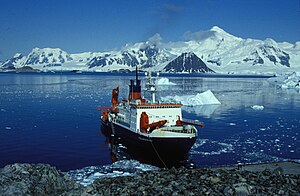
View from the anchorage at Rothera station with the German research vessel Polarstern to the south over Ryder Bay to the Princess Royal Range with Mount Gaudry as the highest point |
||
| height | 2315 m | |
| location | Adelaide Island , West Antarctica | |
| Mountains | The Princess Royal Range | |
| Coordinates | 67 ° 32 '15 " S , 68 ° 37' 49" W | |
|
|
||
| Normal way | Alpine tour (glaciated) | |
Mount Gaudry ( French Sommet A. Gaudry, Massif Gaudry ) is a 2315 m (according to the UK Antarctic Place-Names Committee 2320 m ) high mountain in the south of the Adelaide Island west of the Antarctic Peninsula . It rises immediately southwest of Mount Barré and 8 km north-northwest of Mount Liotard in the Princess Royal Range . It is the highest point in this mountain range.
The mountain was discovered and named during the Fifth French Antarctic Expedition (1908–1910) under the direction of polar explorer Jean-Baptiste Charcot . Charcot named it after the French geologist and paleontologist Albert Gaudry (1827-1908), who had been a member of the expedition committee. The UK Antarctic Place-Names Committee transferred the name in 1953 in an adapted form into English.
Web links
- Mount Gaudry in the Geographic Names Information System of the United States Geological Survey (English)
- Mount Gaudry on geographic.org (English)

