Ryder Bay
| Ryder Bay | ||
|---|---|---|
|
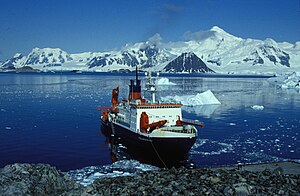
View from the anchorage at the Rothera station with the German research vessel Polarstern to the south over Ryder Bay |
||
| Waters | Marguerite Bay | |
| Land mass | Adelaide Island , West Antarctica | |
| Geographical location | 67 ° 33 '58 " S , 68 ° 19' 59" W | |
|
|
||
| width | 10 km | |
| depth | 6.5 km | |
| Islands | Léonie Islands | |
| Tributaries | Horton Glacier , Hurley Glacier , Sheldon Glacier , Turner Glacier | |
The Ryder Bay , a 10 km wide and 6.5 km long bay on the southeast coast of the West Antarctic Adelaide Island km 8 east of Mount Gaudry . The Léonie Islands are in the entrance to this bay.
It was discovered and measured for the first time in 1909 during the Fifth French Antarctic Expedition under the direction of polar explorer Jean-Baptiste Charcot . The British Graham Land Expedition (1934–1937) led by the Australian polar explorer John Rymill and the Falkland Islands Dependencies Survey in 1948 carried out new surveys. The bay is named after Lisle Charles Dudley Ryder (1902–1940), second mate on the Penola during Rymill's expedition.
Web links
- Ryder Bay in the Geographic Names Information System of the United States Geological Survey (English)
- Ryder Bay on geographic.org (English)

