The Princess Royal Range
| The Princess Royal Range | ||
|---|---|---|
|
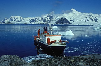
View from the anchorage at Rothera Station with the German research vessel Polarstern to the south over Ryder Bay to the Princess Royal Range |
||
| Highest peak | Mount Gaudry ( 2320 m ) | |
| location | Adelaide Island ( West Antarctica ) | |
|
|
||
| Coordinates | 67 ° 32 ′ S , 68 ° 35 ′ W | |
The Princess Royal Range ( English ) is a mountain range in the south of the Adelaide Island west of the Antarctic Peninsula . It extends from McCallum Pass in the north to Cape Alexandra in the south.
Participants in the Fourth French Antarctic Expedition (1903-1905) led by polar explorer Jean-Baptiste Charcot erroneously mapped it as part of Graham Land . The Falkland Islands Dependencies Survey carried out a new survey in 1948. Aerial photographs were taken between 1956 and 1957 during the Falkland Islands and Dependencies Aerial Survey Expedition . The UK Antarctic Place-Names Committee named it in 2006 after Anne, Princess Royal (* 1950), the only daughter of Queen Elizabeth II of England .

