
Mount Napier
| Mount Napier | ||
|---|---|---|
 Mount Napier |
||
| height | 440 m | |
| location | Victoria , Australia | |
| Coordinates | 37 ° 53 '38 " S , 142 ° 3' 32" O | |
|
||
| rock | Lava , volcano | |

Mount Napier in Victoria is one of the youngest volcanoes in Australia .
description
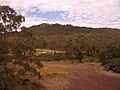
Mount Napier is located in Mount Napier State Park about 270 km west of Melbourne and 17 km from Hamilton . The volcano was last active 5,290 years before our era. The lava flow from Mount Napier reached up to Mount Eccles , about 25 km southwest along the Harmans Valley to Byaduk North . The lava created basalt mounds. These hills, also called tumuli in Australia , are unique to the Australian continent and are rare in the rest of the world. They were formed by gas leakage and heat as the lava rose to the surface. Some quarries and lava tubes are located near Byaduk .
Mount Napier has a composite lava shield with a superposed cinder cone . The cone rises 150 m above the surrounding plain, the mountain reaches a height of 440 m and makes up the highest point of the plain in the Western District Plain of Victoria. Mount Napier is part of the geological Newer Volcanics Province , which formed the youngest volcanic center in Australia. It covers an area of 15,000 km² and has 400 volcanic vents.
photos
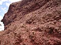
Eroded lava from Mount Napier
View of the volcanic rim

View from Harmans Valley to Mount Napier
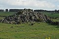
Eroded lava hill


.JPG)
_-_Byaduk_-_Victoria_-_Australia.JPG)
Individual evidence
- ↑ - ( Memento of the original of September 13, 2009 in the Internet Archive ) Info: The archive link was automatically inserted and not yet checked. Please check the original and archive link according to the instructions and then remove this notice.