Municipio Cardenas (Tabasco)
| Cardenas | |
|---|---|

|
|
| Basic data | |
| Country | Mexico |
| State | Tabasco |
| Seat | Cardenas |
| surface | 2,055.6 km² |
| Residents | 248,481 (2010) |
| density | 120.9 inhabitants per km² |
| INEGI no. | 27002 |
| politics | |
| Presidente municipal | Rafael Acosta León |
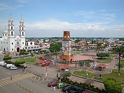
| Parque Independencia in the city of Cardenas | |
Coordinates: 18 ° 0 ′ N , 93 ° 24 ′ W
Cárdenas is a municipality in the Mexican state of Tabasco . The municipality extends over an area of 2055.6 km², the 2010 census counted 248,481 inhabitants in the municipality. The administrative seat is the homonymous Cárdenas . The municipality and its main town are named after the founder of the main town, José Eduardo de Cárdenas y Romero.
geography
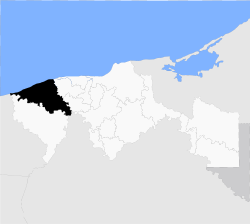
The municipality of Cárdenas is located in the west of the state at altitudes below 100 m in the Subregión de Chontalpa of the Región del Río Grijalva . It belongs entirely to the physiographic province of the southern coastal plain of the Gulf of Mexico. A good 93% of the municipality is in the basin of the Río Tonalá , the rest in the basin of the Carmen and Machona lagoons. Alluvions predominate in the municipal area , the predominant soil types are vertisol (53%) and gleye (23%). About 43% of the municipality is used as pasture land, about a quarter as arable land.
The municipality of Cárdenas borders the municipalities Paraíso , Comalcalco , Cunduacán and Huimanguillo and, through river borders, the Mexican states of Chiapas and Veracruz and the Gulf of Mexico .
population
The 2010 census counted 248,481 people in 59,591 residential units in the municipality, making it the municipality with the second largest population in the state. 1,021 people were registered as speakers of an indigenous language , including 201 Nahuatl speakers and 143 Zapotec speakers . Almost 7.4% of the population were illiterate. 84,545 residents of Cárdenas were registered as economically active, of which about 77% were men and 4.7% were unemployed. Just over twenty percent of the population lived in extreme poverty.
places
The municipality of Cárdenas comprises 172 inhabited localidades , 21 of which are classified as urban by the INEGI . Four places had a population of over 5000 in the 2010 census, another 40 places had at least 1000 inhabitants. The biggest places are:
Web links
- Enciclopedia de los Municipios y Delegaciones de México: Municipio Cárdenas (Spanish)
- INEGI : Datos Geográficos: Municipio Cárdenas (Spanish; PDF)

