Munzur Dağları
| Munzur Dağları | |
|---|---|
|
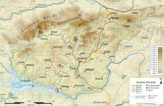
The Munzur Dağları are located on the northwestern provincial border (Çiyayên Mizur) |
|
| Highest peak | Akbaba ( 3482 m ) |
| location | Tunceli and Erzincan provinces , Turkey |
| Part of | Taurus Mountains |
| Coordinates | 39 ° 26 ' N , 39 ° 3' E |
The Munzur Mountains ( Munzur Dağları , also Munzur Sıradağları or Mercan Sıradağları ) is a mountain range in Turkey . The mountains are a continuation of the Taurus Mountains to the east and form the border of the Turkish provinces of Tunceli and Erzincan . It extends from Kemaliye in an east-west direction over about 130 km, the central north-south axis lies roughly between the cities of Erzincan and Tunceli , here the mountains are about 30 km wide.
The Munzur Mountains take their name from the 2698 m high Munzur Dağı (Koê Muzıri) in the Ovacık district , which is located in the west of the mountain range and is separated from the rest of the Munzur Sıradağları by a saddle . The name Mercan Sıradağları is based on the mountain range of the same name in the east, which reaches a height of 3292 m.
In the Munzur Mountains there are frequent battles between the Turkish armed forces and the PKK .
geography
The highest point of the chain is the Akbaba at 3482 m in the far east. Other peaks are Ziyarettepe (3118 m), Kurtlukar Tepesi (approx. 2859 m), giltepe , Haraminin Tepe (approx. 2347 m), Kuştepe (approx. 2743 m) and Gediktepe . The main drainage arteries of the mountains are the Karasu , one of the two headwaters of the Euphrates , and the Ziyaretdere , which flows into them. Typical of the mountain range are glacial lakes and oak forests.
Part of the mountain belongs to the Munzur Valley National Park . The national park is called Munzur Vadisi Milli Parkı in Turkish and covers an area of 42,000 hectares. It was founded in 1971 and has not yet been developed. The region around the valley of the Munzur River is covered with oak forests in the higher elevations. Nut trees, alders and ash trees grow in the valley. The boundaries of the national park begin eight kilometers from the provincial capital Tunceli.
geology
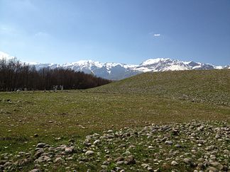
The mountain range consists mainly of limestone , serpentinite and Neogene sedimentary rocks . The structure of the mountains is determined by the thrust of the serpentinites and the limestones on top of them in the north over the sediments in the south. The rocks determine the appearance of the mountains: the limestone forms an inaccessible alpine landscape with rugged rock faces and little vegetation. Gentle forms can be found in the serpentine areas, which are also poorly overgrown, and the agriculturally usable neogene sediments.
Munzur
The name Munzur is also the name of a river that flows through Tunceli. It flows into the Murat , one of the source rivers of the Euphrates. It was named after the shepherd Munzur Baba , who, according to a legend, shed buttermilk at what is now the spring, causing the 40 springs of Munzur to come into being.
literature
- Türkiye Coğrafya Atlası (Geographical Atlas of Turkey), DBR, İstanbul 2004, pp. 51–52.
Web links
- Karl Nebert: Data on the geology of the Munzur Dağ area. (PDF file; 602 kB)
- The mountains of Turkey - an overview map
References and comments
- ↑ Turkey map of the Faculty of Geography at Ankara University
- ↑ GeoNames gives 2555 m for the Akbaba Tepesi in the east of the mountains
- ^ Heights of GeoNames, http://www.geonames.org

