Sewerny Ui
|
Severny Ui Северный Уй |
||
|
|
||
| Data | ||
| Water code | RU : 18030600512117300024563 | |
| location | Khabarovsk region ( Russia ) | |
| River system | Lena | |
| Drain over | Maja → Aldan → Lena → Arctic Ocean | |
| source | in Dzhugdzhur Mountains -Gebirge 57 ° 22 '37 " N , 138 ° 49' 28" O |
|
| muzzle | in the Maja coordinates: 57 ° 49 ′ 47 " N , 136 ° 17 ′ 27" E 57 ° 49 ′ 47 " N , 136 ° 17 ′ 27" E
|
|
| length | 233 km | |
| Catchment area | 18,200 km² | |
| Left tributaries | Chelassin | |
| Right tributaries | Totta , Njot | |
|
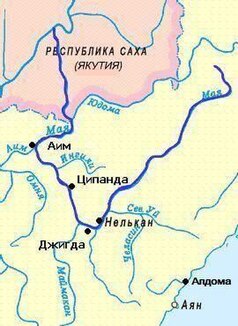
Course of the Severny Ui (Сев. Уй) |
||
The Severny Ui ( Russian Северный Уй , "Northern Ui") is a left tributary of the Maja in the Khabarovsk region in the Far East of Russia .
The Severny Ui rises in the Jugdschur Mountains not far from the coast of the Sea of Okhotsk . It flows inland in a westerly direction. It takes in the Tschelassin tributaries from the left and the Totta and Njot from the right. The Severny Ui meets the Maja after 233 km, which is part of the Lena river system . The Severny Ui drains an area of 18,200 km².
Individual evidence
- ↑ a b Severny Ui in the State Water Directory of the Russian Federation (Russian)
