Maja (Aldan)
|
Maja Мая, Майя (Maija) |
||
|
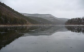
Maja in mid-October |
||
| Data | ||
| Water code | RU : 18030600512117300022262 | |
| location | Khabarovsk Region , Sakha (Yakutia) Republic ( Russia ) | |
| River system | Lena | |
| Drain over | Aldan → Lena → Arctic Ocean | |
| origin | Confluence of the Left and Right Maja in the Judoma Maja Highlands 59 ° 44 ′ 50 ″ N , 139 ° 37 ′ 45 ″ E |
|
| Source height | approx. 650 m | |
| muzzle | at Ust-Maja in the Aldan coordinates: 60 ° 24 ′ 16 ″ N , 134 ° 33 ′ 10 ″ E 60 ° 24 ′ 16 ″ N , 134 ° 33 ′ 10 ″ E |
|
| Mouth height | 153 m | |
| Height difference | approx. 497 m | |
| Bottom slope | approx. 0.47 ‰ | |
| length | 1053 km | |
| Catchment area | 171,000 km² | |
| Discharge at the Tschabda A Eo gauge : 165,000 km² Location: 88 km above the mouth |
MNQ 1935/1999 MQ 1935/1999 Mq 1935/1999 MHQ 1935/1999 |
54 m³ / s 1159 m³ / s 7 l / (s km²) 3882 m³ / s |
| Left tributaries | Aim , Maimakan , Batomga , Severny Ui | |
| Right tributaries | Judoma , Ingili | |
| Communities | Aim | |
| Navigable | 500 km | |
|
Course of the Maja |
||
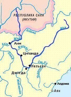
The Maja ( Russian Мая ; also Майя / Maija ) is a 1053 km long, right or eastern tributary of the Aldan in the Far East Federal District ( Russia , Asia ). It runs through the Khabarovsk region and the Sakha Republic (Yakutia) .
The river arises in the northern part of the Judoma-Maja highlands from the short source rivers Left Maja ( Lewaja Maja ; with about 30 km the longer one) and Right Maja ( Prawaja Maja ). It initially flows through the highlands west of the Jugdschur Mountains in a predominantly south-westerly direction and bends to the north-west below Nelkan . Later it runs northwards from Aim and crosses the border with Sakha (Yakutia). Finally, the Maja flows into the Aldan, the largest tributary of the Lena, at Ust-Maja .
The catchment area of the Maja covers 171,000 km². The frozen from late October to May River is about 500 km long from its mouth upriver navigable . One of its largest tributaries is the Judoma .
swell
- Maja ( Memento from May 21, 2008 in the Internet Archive ) in the Yakutia Geographical Manual (website of the Ministry of Nature Conservation of the Republic of Sakha (Yakutia) in Russian; accessed on February 18, 2011)
Individual evidence
- ↑ a b c Maja in the State Water Directory of the Russian Federation (Russian)
- ↑ a b Article Maja in the Great Soviet Encyclopedia (BSE) , 3rd edition 1969–1978 (Russian)
- ↑ Maja at the Tschabda gauge - hydrographic data at R-ArcticNET

