Jugdschur
| Jugdschur | ||
|---|---|---|
| Highest peak | Topko ( 1906 m ) | |
| location | Khabarovsk region ( Russia ) | |
|
|
||
| Coordinates | 58 ° 0 ′ N , 136 ° 0 ′ E | |
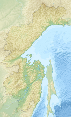
The Dschugdschur ( Russian Джугджур ; also Dschugdschur Mountains, Dshugdshur, Dzhugdzhur) is a mountain range in the Far East of Russia ( Asia ) along the northwest coast of the Sea of Okhotsk .
geography
The Jugdschur stretches in a slightly curved arc over 700 km along the northwest coast of the Sea of Okhotsk, roughly in a southwest-northeast direction. It is dominated by low mountain ranges at altitudes between 800 and 1200 m. However, the relief of parts of the main ridge in its highest sections is alpine as a result of earlier glaciation. The highest point is the Topko (Топко) with a height of 1906 m above sea level in the central part of the mountain, about 85 km northwest of the village of Ajan and a little west of the main ridge (or, according to information in a more recent map, an unnamed peak 8 km southwest of the Topko with 1925 m, while the Topko itself only reaches 1889 m according to this map).
In the north, the Jugdschur borders on the southeastern foothills of the Verkhoyansk Mountains . In the south it goes over the valley of the Uda into the Jagdy Mountains , and in the south-west it borders the Stanowoy Mountains .
In some sections of the mountain range, other lower ridges, separated by long valleys, run parallel to the main ridge. The most important is the coastal chain (Прибрежная цепь, Pribreschnaja zep), which runs between the main ridge and the coast of the Sea of Okhotsk, southwest of Ayan and reaches an altitude of 1416 m (Unytschja, Унычья).
The main ridge of the Dzhugdzhur Mountains represents a portion of the continental watershed between the basin of the Arctic Ocean belonging flow system of the Lena represents and the basin of the Okhotsk. While the mountains on the north west edge rises relatively flat, which is directed towards the sea south side is steep and highly structured. The largest river flowing in the north-west (to Aldan or Lena ) is the Maja with its tributaries Maimakan (Маймакан), Batomga (Батомга), Northern Ui (Северный Уй, Severny Ui), Chelassin (Челасин), Chelassin (Челасин) Nudymi (Нудыми), Jadra (Ядра). The largest rivers draining into the Sea of Okhotsk are the mostly short but water-rich rivers Aldoma (Алдома), Ulkan (Улкан), Etanja (Этанджа), Untschi (Унчи) and Ulja (Улья) (in each case according to the order of their confluence from south to north where the Etandscha flows into the Tuktschi (Тукчи) 9 km from the Sea of Okhotsk ).
Administratively, the territory of the mountain range lies entirely within the northwest part of the Khabarovsk Territory .
geology
The Jugdschur is a tectonically young mountain range. Its southwestern part is formed by uplifted late Precambrian granites and gneiss , the northeastern part by slate and limestone folded in the Mesozoic Era , which are covered by thick layers of lava and tuff from the Paleogene .
climate
Climatically, the mountains can be divided into two zones. North-west of the main ridge, the climate is strictly continental with winter temperatures of −40 to −45 ° C and short hot summers and low rainfall all year round. In the coastal zone southeast of the main ridge, there is a cold, damp monsoon climate with cold winters (−16 to −20 ° C) and cool, rainy summers. The number of hours of sunshine is low here, but storms are frequent.
vegetation
On the coast side, the dwarf pine ( Pinus pumila ) predominates in the areas near the shore . Mountain taiga with a dominant Ajan spruce ( Picea ajanensis ) follows up to about 1300 m , on the northwestern side there is Dahurian larch ( Larix dahurica ). The ridge area is dominated by dwarf pine, Krummholz and mountain tundra .
natural reserve
In the area of the Jugdschur lies the Dschugdschur nature reserve (Джугджурский заповедник) with an area of 859,956 hectares , which was placed under protection in 1990 and is intended to preserve previously undisturbed mountain taiga landscapes and their flora and fauna.
population
The Jugdschur area is extremely sparsely populated. The Ajan-Maja- Rajon (Аяно-Майский район, named after the place Ajan and the river Maja), in which the largest, central part of the mountains is located, covers an area of 167,000 km² (almost half the area of Germany) only 3000 inhabitants, corresponding to 0.02 inhabitants / km². There are only four villages located on the coast and in the river valleys west of the mountains (the district center of Ajan as well as Aim, Jigda and Nelkan), while there are no settlements in the actual mountains. Over 40% of the population are members of the indigenous peoples of the Russian north , especially the Evenks , which is a high value for the north of Russia.
Web links
- Article Dschugdschur in the Great Soviet Encyclopedia (BSE) , 3rd edition 1969–1978 (Russian)
- Ayan Maja Raion on the official website of the Khabarovsk Territory (Russian)
- Jugdschur Conservation Area (Russian)
Individual evidence
- ↑ Soviet General Staff Map 1: 200,000. Sheet O-53-XXX (Edition 1989)
