Nagaur
| Nagaur | ||
|---|---|---|
|
|
||
| State : |
|
|
| State : | Rajasthan | |
| District : | Nagaur | |
| Sub-district : | Nagaur | |
| Location : | 27 ° 12 ′ N , 73 ° 44 ′ E | |
| Height : | 295 m | |
| Residents : | 102,872 (2011) | |
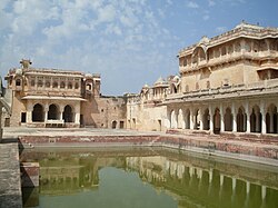
| Nagaur Fortress | ||
Nagaur is a city in the Indian state of Rajasthan .
Nagaur is the administrative center of the district of the same name . The city is located 200 km west of Jaipur . The national highways NH 65 ( Jodhpur - Hisar ) and NH 89 ( Bikaner - Ajmer ) cross in Nagaur. In the 2011 census, the population was 102,872. In Nagaur there is an old fortress from the early 12th century.
Web links
Commons : Nagaur - collection of images, videos and audio files

