Nanumanga
| Nanumanga | ||
|---|---|---|
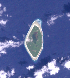
| NASA image of Nanumanga | ||
| Waters | Pacific Ocean | |
| Archipelago | Tuvalu | |
| Geographical location | 6 ° 17 ′ 14 ″ S , 176 ° 19 ′ 3 ″ E | |
|
|
||
| length | 3 km | |
| width | 1.5 km | |
| surface | 2.78 km² | |
| Residents | 481 (2012) 173 inhabitants / km² |
|
| main place | Tokelau | |
Nanumanga (also Nanumaga ) is an island in the Pacific state of Tuvalu and one of the country's eight districts. The main town is Tokelau . The island has 481 inhabitants (as of 2012) in two villages. Historically, the island was divided into three districts: Tonga , Tokelau, and Lemuli . Of these, only Toga (formerly Tonga ; 236 inhabitants) and Tokelau (245 inhabitants) are still inhabited. Both villages are in the immediate vicinity on the west coast; Tokelau is north of Tonga. The island is 2.78 square kilometers.
history
In 1986 divers discovered the underwater caves of Nanumanga 40 meters below the water , in which evidence of a settlement of the island since 6000 BC was found.
geography
Nanumanga is about three kilometers long and 1.5 kilometers wide. The northernmost point is Te Kaupapa , the southernmost point is Te Papa . There is a small salt water lake on the island called Vaitoa where mangroves grow. There is a stone path through the lake that connects the two villages on the island of Toga and Matematefaga . There are also two smaller saltwater lakes in the south of the island, Loto'aiga and Haapai .
Web links
- Detailed information (English)
Individual evidence
- ^ Falekaupule Act. Government of Tuvalu, 1997, No. 8; 2008 revised edition, CAP. 4.08, Schedule 1, p. 56, accessed on July 29, 2014
- ^ Tuvalu Online GIS. Tuvalu Central Statistics Office, January 2015, accessed January 8, 2015 .
- ↑ The Fire Caves of Nanumaga. The Age (Australia), April 13, 1987, from TuvaluIslands.com. Retrieved July 25, 2014
- ^ Map of Nanumaga. TuvaluIslands.com, date unknown retrieved July 25, 2014

