Oelingrather and Grunder Bachtal nature reserve
The nature reserve Oelingrather and Grunder Bachtal with a size of 22.2 hectares is located northwest of Remscheid , northeast of Solingen and south of Wuppertal . The area was designated as a nature reserve (NSG) by the city of Remscheid in 2003 with the designation RS-012.
Area description
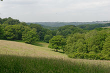
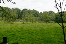
The NSG "Oelingrather und Grunder Bachtal" consists of two stream valleys south of the village of Grund and south of the village of Oelingrath . They are spatially separated by the village of Grund. The near-natural brooks had spring areas and water mosses in sections (zFM1). Butterbur stocks have formed in the stony to loamy stream bed . The streams meandering in the relatively narrow Kerbtal are mostly agriculturally used grassland areas. In places, both the flowing waters (zAC5) and the areas adjacent to the road are lined with smaller trees. In the grassland near the stream, there are moist stands of marsh marigolds and poor pastures have developed on the slopes. Bracken or neophytes have grown on smaller sections . The higher lying deciduous forests (beech forest xAA0, beech-oak forest AB1 and birch-oak forest AB2) are heterogeneous in terms of age and species. After successful maintenance measures, Besenheide initially settled in the northern part of the NSG. A still water with a shield buttercup located north near Kempkenholz is currently (2011) separated from the flowing water and renatured. A forest burial site and park-like relics connect to the east and west of the still water. A particularly species-rich spring can be found south of the still water. The still waters in the southern part of the NSG are old, partly shaded fish ponds with a narrow bank zone.
With its near-natural brook course and the existing floodplain dynamics, the punctual spring meadows, its banks rich in tall forebears, the streams of alder trees, the wet and lean grassland, the individual bushes and the near-natural deciduous forest with interspersed old wood, the landscape is typical of the Bergisches Land natural area.
The structural diversity, the occurrence of endangered species and the good conservation status give this area an excellent place among comparable areas in the natural space. Due to its typical shape and the wealth of biotope types and near-natural structures, it is of national importance. In the regional environment it can be seen as a stepping stone in the network of near-natural notch valleys. It is also used locally for local recreation.
The development goals lie in the maintenance and promotion of the structural diversity of typical landscape and near-natural notch valleys with natural stream courses, tall herbaceous meadows, the predominantly wooded slope areas, the peculiarity and beauty of the meadow valleys as well as the existing near-natural still waters.
Biotope types in the area
- Natural eutrophic lakes with magnopotamion or hydrocharition <3150> (0.09 ha) vegetation
- Streams of the planar to montane level with vegetation of the Ranunculion fluitantis and the Callitricho-Batrachion <3260> (0.14 ha)
- Moist tall herbaceous vegetation of the planar and montane to alpine level <6430> (0.06 ha)
- Alluvial forests with Alnus glutinosa and Fraxinus excelsior (Alno-Padion, Alnion incanae, Salicion albae) <91E0> (0.29 ha)
- Deciduous forests that are worthy of protection and endangered outside of special locations (not FFH-LRT) <NA00> (5.90 ha)
- Linear woody structures and individual trees worthy of protection and endangered <NBD0> (1.28 ha)
- Bank trees that are worthy of protection and endangered (not FFH-LRT) <NBE0> (0.03 ha)
- Marshes, reeds and reed beds worthy of protection and endangered (not FFH-LRT) <NCC0> (0.01 ha)
- Wet and damp grassland that is worthy of protection and at risk, including fallow land (not FFH-LRT) <NEC0> (0.12 ha)
- Lean grassland worthy of protection and endangered including fallow land (not FFH-LRT) <NED0> (1.82 ha)
- Still waters worthy of protection and endangered (not FFH-LRT) <NFD0> (0.01 ha)
- Source areas worthy of protection and endangered (not FFH-LRT) <NFK0> (0.02 ha)
- Watercourses worthy of protection and endangered (not FFH-LRT) <NFM0> (0.45 ha)
Protected biotopes
- Alluvial forests (0.32 ha)
- Running water areas (natural or near-natural, undeveloped) (0.64 ha)
- Spring areas (0.02 ha)
- Reed beds (0.01 ha)
- Wet meadows rich in sedge and rushes (0.12 ha)
- standing inland waters (natural or near-natural, undeveloped) (0.10 ha)
Web links
- Nature reserve “Oelingrather and Grunder Bachtal” (RS-012) in the specialist information system of the State Office for Nature, Environment and Consumer Protection in North Rhine-Westphalia
Coordinates: 51 ° 12 ′ 12.4 " N , 7 ° 10 ′ 55.5" E


