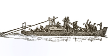
Nauffahrt

As Naufahrt was formerly called the drifting downstream of ships on the Danube and its tributaries between Ulm and Hungary . The rudder was mounted on the bow to steer the barges . The one-way boat type of the Ulmer Schachtel has only been used for sea travel since the Middle Ages to transport goods and passengers.
The opposing journey upstream is called counter-drive (no longer in use today), respectively. Horses pulled the boats on the hoof loft , the towpath or the accompanying road. Even today, numerous names of old arms, street names and parts of the municipality are reminiscent of the Naufahrt.
Nauffahrt was also the name for the downhill salt ship itself.
Nautical boat for depth measurement
The water depth of a waterway in the river was measured before the echo sounder was introduced using wooden probing rods that are typically 6–8 m long and 5–6 cm in diameter. In order to reduce the - large - effort required to handle the rod when probing, it is necessary to drive up close, i.e. to let the watercraft drift with the current with the bow aligned approximately in the direction of flow.
A strong man stands on the side edge of a raft or near the side of a boat that is not too narrow and therefore safe from tipping over and sticks the probing rod slightly downstream into the water until he feels that the rod is standing on the bottom. After reading the scale on the rod, the person carrying out the probe calls up the measured depth in decimeters and pulls the rod back up and completely out of the water.
Viscosity causes water near the bottom of a river to flow more slowly than the surface current. Only very slow currents in shallow waters (low Reynolds number ) build up a linear velocity profile through laminar flows : From the bottom to the surface of the water, the speed increases proportionally with the distance to the bottom. However, turbulence is typical, so that in half the depth of the water there is significantly more than half to almost the full surface flow velocity.
Even before the probing rod “finds” the bottom, it penetrates the water layers close to the ground, which - from the point of view of the boat drifting in line with the surface current - clearly “flow backwards (= to the stern)” and are thereby distracted. If the rod finally hits the ground - haptically perceptible - it is instantly “taken along” at its lower end and rotates around a horizontal axis across the flow of the river. The water depth is best read, because it is most accurate, at the moment when the rod is vertical. Whether in the direction of gravity or at right angles to the surface of the water makes no significant difference with the slight gradient of navigable waters. While the rod is pulled up from the depths, it rotates with momentum, slowed down by higher layers of water. If the rod is pulled out far enough, it will be supported by the hands below the center of gravity and will tilt with the upper end down by itself. With a skilful sequence of movements, the rod can now be inserted with the other end - alternating in each case - without any effort to turn it over to the front.
Echo sounders have been used for depth measurements for around 100 years, but probing rods are still on many ships on the Via donau , which maintains the Danube shipping route in Austria (including small sections of the Traun and Enns near the mouth of the river ).
In the case of the Via donau , the term Nauffahrt has been retained in Austria for the regular measurement trips along the shipping channel. The routine measurements are carried out by the two navigation boats "Halbe Meile" (2016) and Carnuntum (2017) while they are essentially drifting downwards. In order to keep a measured depth profile comparable to the previous one, certain driving lines are adhered to. These must be adhered to by lateral steering with low engine power. Low speed compared to the surrounding water avoids measurement errors, which result from the fact that the boat rises in front or lifts out of the water altogether. The single-beam echo sounder with a small (7.5 °) beam width is mounted about a sixth of the boat length behind the center of the boat in the underside of the hull, because this is where the axis of rotation for pitching (pitching) the boat lies .
Although these boats travel upriver at speeds of up to 65 km / h, their entire use is referred to as approaching in the broader sense .
This does not include the detailed measurements with the fan-type echo sounder, also at an angle to the side and almost to the surface of the water, which measures the river bed, installations and obstacles over an area. These are done with other boats.
See also
Web links
Individual evidence
- ↑ NAUFAHRT, f.. In: Jacob Grimm , Wilhelm Grimm (Hrsg.): German dictionary . tape 13 : N, O, P, Q - (VII). S. Hirzel, Leipzig 1889 ( woerterbuchnetz.de ).
- ↑ Half a mile - survey boat - N-10.425 binnenschifferforum.de ; accessed July 2, 2018.
- ↑ News oeswag-werft.at; accessed July 2, 2018.
- ↑ Note. Measurements are taken four to ten times a year, about three profiles lying next to each other in the river.
- ^ Markus Simoner: Nauffahrt . viadonau.org, March 13, 2018; accessed July 2, 2018.
- ↑ Tel. Info. Mr. Held, Head of Surveying at via donau, July 2, 2018.