Niedów Reservoir
| Niedów Reservoir | |||||||||
|---|---|---|---|---|---|---|---|---|---|
| The dam after the break | |||||||||
|
|||||||||
|
|
|||||||||
| Coordinates | 51 ° 2 '31 " N , 14 ° 58' 56" E | ||||||||
| Data on the structure | |||||||||
| Lock type: | Earthfill dam | ||||||||
| Construction time: | 1958–1962 | ||||||||
| Height above valley floor: | 15 m | ||||||||
| Height above foundation level : | 18 m | ||||||||
| Height above the river bed : | 11 m | ||||||||
| Height of the structure crown: | 211.70 m npm | ||||||||
| Building volume: | 110 000 m³ | ||||||||
| Crown length: | 270 m | ||||||||
| Power plant output: | 0.8 MW | ||||||||
| Data on the reservoir | |||||||||
| Altitude (at congestion destination ) | 210 m npm | ||||||||
| Water surface | 175.9 ha | ||||||||
| Storage space | 4,807,000 m³ | ||||||||
The Niedów Reservoir or Witka Reservoir ( Polish: zbiornik wodny Niedów ) is a reservoir near Niedów ( German Nieda ) in the Polish part of Upper Lusatia . The water of the dammed Witka (Wittig) , a right tributary of the Lusatian Neisse , serves as process water for the Turów power plant .
As a result of a flood, the dam, built between 1958 and 1962, was destroyed on August 7, 2010, causing flooding along the Witka and Neisse rivers. During the reconstruction of the dam, greater attention was paid to flood protection.
geography
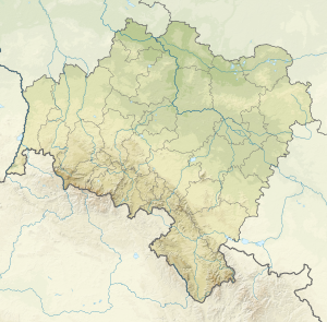
The reservoir is located on the border of the rural community Zgorzelec (Görlitz) with the rural community Sulików (Schönberg) and the township Zawidów (Seidenberg) in the Lower Silesian Voivodeship . It extends over about three kilometers in length, its maximum width is about 900 meters.
Two kilometers west of Leuba lies the border with Germany, one kilometer southeast of Ves (meadow) with the Czech Republic. Surrounding villages are Niedów (Nieda) and Wilka (Wilke) in the north, Wilka-Bory and Ksawerów (Zwecka) in the northeast, Spytków (Wanscha) in the south and Ręczyn (Reutnitz) in the southwest.
The reservoir is a recreational area and is used for swimming, sailing and fishing. Its water is brownish clouded by floating debris from the moors of the Jizera Mountains .
history
construction
The dam on the Witka was built between 1958 and 1962 as a cooling water reservoir for the Turów power plant . Most of Niedów, parts of Spytków and several mills were demolished. The almost 300 meter long concrete earth dam was 15 meters high and was completed in 1962. The reservoir contained 4,807,000 m³ of water. It was used as a process water reservoir and for recreational purposes and had no flood protection function.
Dam break
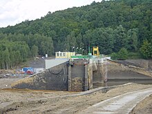
After heavy rainfall in the region on August 7, 2010, the reservoir was no longer able to absorb the incoming water from the Witka, after which the dam and its bank areas were flooded over a length of about 300 meters. As a result, the dam body, consisting mainly of gravel, sand and clay, was almost completely washed out within a few hours. The middle section made of concrete with the three locks and the hydroelectric power station remained.
procedure
On August 6th, 60 to 100 mm of rain was predicted in the catchment area . On the morning of August 7th, a tidal wave of 160 m³ / s developed from the upper reaches of the Czech Republic. This information was found on Czech flood monitoring websites, but was not initially considered to be dramatic. The tidal wave hit the reservoir at the tributary of the Witka at around 2:00 p.m., at 2:15 p.m. 30 m³ / s were measured. From then on, the dam's flaps (three segment gates ) were gradually opened and the water level was lowered from 210 m (full damming) to 209.80 m. A faster opening was not permitted because otherwise the discharge in the lower reaches would have increased too quickly. At 3:00 p.m. the inflow had risen to 240 m³ / s. The fire brigade in Radomierzyce was informed around this time. By 3:50 p.m., the three closures were fully open so that the maximum flow was possible. At around 3:30 p.m., the Starostei of the Powiat Zgorzelecki and the Turów power plant were informed of an unprecedented flood and the fire brigade was called to evacuate. The water continued to rise in the reservoir. Within an hour and a half at most, the space between normal full stowage and the dam crest (the freeboard ), which is 1.70 m high, was filled . This corresponds to an additional amount of water of three to four million cubic meters, which is added to the normal 4.8 million m³ storage capacity. At 5:20 p.m. the water ran across the top of the dam; it reached a height of 50 centimeters. After a maximum of half an hour, the grass on the air side of the dam was worn away by the force of the water. Then, around 6:00 p.m., the dam began to break when the dam body, which was mainly made of sand, collapsed in several places at the same time. The plates on the water side gave way and the whole dam was washed away next to the overflow, except for small remains - in the direction of flow to the right.
tidal wave
In a tidal wave, the water from the reservoir poured over the Witka into the Lusatian Neisse and into the Berzdorf Lake . The tracks of the Neißetalbahn running along the Berzdorfer See were undermined by the tidal wave and thus made impassable. The tidal wave flooded the villages of Radomierzyce (Radmeritz), Hagenwerder and the areas close to the banks of Weinhübels , Görlitz old town, Zgorzelecs , Ludwigsdorfs and other towns downstream. This created a backwater in the Neisse, and the St. Marienthal monastery upstream of the Witka estuary was also flooded. There was one dead from the tidal wave, a fireman in Radomierzyce.
In Görlitz, however, the amount of water from the reservoir may only have contributed to a slight increase in the Neisse level in the general flood situation. The power plant director speaks of 5 million m³ of reservoir content and 100 million m³ of total flow rate in the Neisse.
After the dam broke, the residents in the lower reaches of the river were warned of the tidal wave very late and in parts. At first, the German authorities knew nothing about the breach of the dam, only about increased drainage. While Zgorzelec was able to take precautions, Görlitz on the opposite side of the Neisse remained without information. Because of the floods, the city of Görlitz later reported the operator of the power plant to the public prosecutor's office for negligent causing a flood.
Investigations afterwards
In 2013, German authorities published a report on the 2010 flood, which also examined the causes of the dam breach. The three locks of the dam could be raised mechanically to a lifting height of 250 cm. At this point there was an automatic limit switch so that they could only have been opened further by hand, namely up to 500 cm. According to the records in the operating log, all locks were raised to 250 cm at 3:30 p.m., the time of the power failure. According to the automatic recordings, however, two of them were only raised to different heights, namely 150 and 170 cm. After the dam broke and some time later, all three were at a height of 250 cm. With a complete opening to 500 cm, the flood could have passed through without overflowing the dam, i.e. without breaking the dam. The Polish public prosecutor's office initiated an investigation against the operating personnel of the Turów power plant. It was discontinued in 2012 because no criminal offenses could be established. In addition, it was found that the floods would only have been smaller in certain places without the dam breach, since in this case too, runoffs of over 700 m³ / s would have flowed into the Neisse. According to computational modeling, the Görlitz gauge only rose to a water level up to 12 cm higher due to the dam breach. In the Hagenwerder area, however, the inflow reaching almost 1,400 m³ / s as a result of the dam breach resulted in a level 40 to 50 cm higher according to the same investigation. There was no evidence of malfunctioning, poor maintenance or improper construction of the dam structure. As a result of this, the aim is to improve cross-border communication, especially with regard to the control of the dam. A use of the dam as part of flood protection is only possible to a limited extent due to the limited storage capacity.
New building
The new construction of the dam was built as a pillar dam with an additional, wide overflow in solid concrete. The overflow has an unusual, longitudinally folded shape so that its width is artificially stretched. To further reduce the force of the overflowing water, steps and a stilling basin were built into the underside of the overflow , and boulders were placed in the drainage channel. The part of the dam, which had been preserved when the dam broke and had already been built on a massive scale, with the barrier gates and the cabins for their operation, was preserved in the new construction. The impoundment had not yet taken place in May 2017. The final acceptance of the new dam will take place on January 31, 2018.
Individual evidence
- ↑ kwpsp.wroc.pl: technical data (Polish). Retrieved September 2, 2010 .
- ↑ a b "We could only watch and pray" - Interview with Roman Walkowiak, the general manager of the Turow power plant and master of the dam . In: Saxon newspaper . August 2010.
- ↑ tagesspiegel.de: "Deaths and disaster alarms during floods in Saxony". Retrieved September 2, 2010 .
- ↑ faz.net: “The Neisse just jumped over the wall”. Retrieved September 2, 2010 .
- ↑ maerkischeallgemeine.de "POLAND: The dam as a security risk - after the dam wall at Witka Lake broke, the public prosecutor's office is investigating the operator". (No longer available online.) Formerly in the original ; Retrieved September 2, 2010 . ( Page no longer available , search in web archives ) Info: The link was automatically marked as defective. Please check the link according to the instructions and then remove this notice.
- ↑ das-polen-magazin.de: "Flood: German accusations against Poland". Retrieved September 2, 2010 .
- ↑ Flood event analysis in August and September 2010 and in January 2011 in Saxony, Chapter 9 (pdf, 16.34 MB)
- ↑ Finally sealed!
- International Water Power & Dam Construction ( [1] ) Yearbook 2004


