Koci Potok
|
Koci Potok / Kočičí potok Katzbach, Göhebach |
||
|
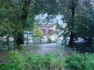
Kočičí potok in Háj during the August flood in 2010 |
||
| Data | ||
| location | Czech Republic , Poland | |
| River system | Or | |
| Drain over | Witka → Lausitzer Neisse → Oder → Baltic Sea | |
| source | near Dolní Oldřiš on the southwest slope of the Bartniki, Czech Republic 50 ° 59 ′ 10 ″ N , 15 ° 9 ′ 45 ″ E |
|
| Source height | 437 m nm | |
| muzzle | in the Niedów reservoir in Witka , Poland Coordinates: 51 ° 1 ′ 49 ″ N , 15 ° 1 ′ 16 ″ E 51 ° 1 ′ 49 ″ N , 15 ° 1 ′ 16 ″ E |
|
| Mouth height | 197 m npm | |
| Height difference | 240 m
|
|
| Left tributaries | Pertoltický potok | |
The Koci Potok (Czech Kočičí potok , German Katzbach , also Göhebach ) is a right tributary of the Witka ( Wittig ) in Poland and the Czech Republic . For most of its course, it forms the border between the two states.
course
The Kočičí potok rises between Dolní Oldřiš , Bulovka and Baranów ( Petersgemeinde ) on the southwest slope of the Bartniki ( shingle fire , 492 m) in the Jizera Mountains foothills near the Polish border in the Czech Republic. The stream first flows around the Bulovský Kopec ( Steinberg , 443 m) to the north and then turns westward, flowing around the Joachimsthaler Stiftswald. Over a length of ten kilometers, the stream forms the border between the Czech Republic and Poland. At Horní Pertoltice the Kočičí potok / Koci Potok changes its course to the north and flows past Łowin ( New Löben ). At the Zadní vrch ( Mittelberg , 308 m) the stream changes its direction to the northwest. The villages of Háj , Stary Zawidów, Habartice and Zawidów follow on both sides of the border . Then the Koci Potok flows into Polish territory and past Ostróżno ( Ostrichen ) and Skiba ( Scheiba ). On its lower reaches the Koci Potok is bridged by the Liberec – Zawidów railway line. At the Zawidów train station, the stream flows into the Niedów reservoir together with the Witka .
history
Since the cession of the Lausitz in the Peace of Prague of 1635, the Katzbach formed the border between the Kingdom of Bohemia and the Electorate of Saxony.
On June 14, 1880, a severe flood of the Katzbach u. a. all lower parts of the city of Seidenberg .
Since the end of the Second World War, the border between Poland and Bohemia has run along the stream.
Tributaries
- Pertoltický potok (l), near Horní Pertoltice
- Račí potok (l), Háj
literature
- Petr David, Vladimír Soukup: Velká turistická encyklopedie - Liberecký kraj . 1st edition. Euromedia Group - Knižní Klub, Prague 2008, ISBN 978-80-242-2326-1
