Jizera foothills
| Jizera foothills | ||
|---|---|---|
|
View from the Jizera Mountains |
||
| Highest peak | Andělský vrch ( 572 m npm ) | |
| location | Poland , Czech Republic | |
| part of | West Sudetes | |
|
|
||
| Coordinates | 50 ° 56 ' N , 15 ° 16' E | |
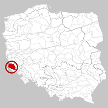
The Jizera Mountains is a hilly region in Poland and the Czech Republic . The area belongs to the Sudetes and forms the geomorphological units Frýdlantská pahorkatina and Pogórze Izerskie in the western Sudeten foreland ( Pogórze Zachodniosudeckie ) . It has an area of 1460 km². The highest point is the Andělský vrch (572 m) in the Czech part.
geography
The Jizera Mountains foothills are north of the Jizera Mountains in Poland and the Czech Republic. Towards the north, near Bolesławiec, the Silesian-Lusatian Plain ( Nizina Śląsko-Łużycka ) joins. In the northeast and east, the Bober valley forms the natural border with the Bober-Katzbach foothills ( Pogórze Kaczawskie ) and Bober-Katzbach mountains . The Hirschberg Valley and the Jizera Mountains to the south join to the southeast . To the west is the Zittau Basin ( Obniżenie Żytawsko-Zgorzeleckie / Žitavská panev ).
The main waters of the Jizera Mountains foothills are the Queis , the Rothwasser , the Wittig and the Küpper , which drain the Lusatian Neisse area and the Bober into the Oder catchment area .
The towns of Frýdlant , Nové Město pod Smrkem , Zawidów , Mirsk , Gryfów Śląski , Leśna , Lubań , Lubomierz and Nowogrodziec belong to the Jizera Mountains foothills .
structure
The Frýdlantská pahorkatina in the Czech Republic forms the southern part of the Jizera foothills. It is identical to the Friedlander Zipfel . The Pogórze Izerskie form the northern part and lie on Polish territory.
Frýdlantská pahorkatina
The Frýdlantská pahorkatina covers an area of 241 km² with an average altitude of 359 m above sea level. M. The highest point is Andělský vrch (572 m).
Subunits are the
- Hejnická pahorkatina ( Haindorf hill country )
- Jindřichovický hřeben ( Heinersdorfer back )
- Libverdská pahorkatina ( Liebwerder hill country )
- Raspenavská pahorkatina ( Raspenau hill country ),
- Větrný
- Bulovská pahorkatina ( Bullendorfer hill country ),
Pogórze Izerskie
The Pogórze Izerskie forms the northern part of the Jizera Mountains foothills and has an area of 1219 km². The highest point is the Wojkowej (502 m) near Giebułtów .
It is divided into sub-units Wyniosłość Działoszyńska, Wysoczyzna Siekierczyńska, Wzgórza Zalipiańskie, Przedgórze Izerskie, Dolina Kwisy, Kotlina Mirska, Przedgórze Rębiszowskie, Wzniesienia Radoniowskie, obniżenie Lubomierskie, Wzgórza Radomickie, Wzniesienia Gradowskie, Niecka Lwówecka, Dolina Bobru, obniżenie Starej Kamienicy and Wysoczyzna Rybnicy.
Attractions
Web links
- http://www.gory.com.pl/pasmagorskie/pogorze_izerskie.php
- http://www.izerska.pl/Pogorze_Izerskie_g,11.html


