Nishiki (river)
|
Nishiki Nishiki-gawa |
||
|
Course of the Nishiki River |
||
| Data | ||
| location | Yamaguchi Prefecture ( Japan ) | |
| River system | Nishiki | |
| source |
Shunan 34 ° 19 ′ 22 " N , 131 ° 45 ′ 43" E |
|
| Source height | 550 m | |
| muzzle | near Iwakuni in the Seto Inland Sea coordinates: 34 ° 9 ′ 0 ″ N , 132 ° 14 ′ 0 ″ E 34 ° 9 ′ 0 ″ N , 132 ° 14 ′ 0 ″ E |
|
| Mouth height | 0 m TP | |
| Height difference | 550 m | |
| Bottom slope | 5 ‰ | |
| length | 110 km | |
| Catchment area | 885 km² | |
| Left tributaries | Shibu-gawa, Goonokawa, Nakanose-gawa, Hongo-gawa, Ikimi-gawa | |
| Right tributaries | Nekasa-gawa, Hoki-gawa, Mishō-gawa | |
| Reservoirs flowed through | Kōdō-ko, Sugano-ko, Yamashiro-ko, Goseno-ko | |
| Small towns | Nishiki | |
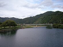
The Nishiki ( Japanese 錦 川 , Nishiki-gawa ) is a river in Yamaguchi Prefecture in Japan . The Kintai Bridge leading over it at Yokoyama makes the river famous far beyond the country's borders.

The river was notorious for its flood disasters, caused by its very wide catchment area of 885 km² and the great drop in the narrow meander river valley. Accordingly, many tributaries and the Nishiki itself have been dammed several times since the middle of the 19th century in order to bring this danger under control. There are six dams on the river, which regulate the water level and provide electricity. The newest unit built is the Hirase Dam, which is also intended to ensure more safety for the town of Nishiki.
geography
course
With a length of 110 km, the river overcomes a height difference of 550 m through the southwestern foothills of the Chūgoku Mountains , its course is very winding with originally very high flow speed.
It has its origin on Mount Azamigatake in the urban district of Shunan , district Oshio (Hanouchi), and flows first southeast to the reservoir Kōdō-ko, flows around the mountain Midoriyama in a semicircle, from there into the reservoir Sugano-ko, in which it flows again makes a bend to the northeast, then in the village of Nishiki turn sharply to the southeast. After flowing through the city of Iwakuni, it finally flows into the Seto Inland Sea . So you can divide the Nishiki in its upper course to the mouth in the reservoir Kōdō-ko and its lower course from the dam Sudano.
Tributaries
Right-sided
- Nekasa-gawa
- Hoki-gawa
- Mishō-gawa
Left-sided
- Shibu-gawa
- Goonokawa
- Nakanose-gawa
- Hongo-gawa
- Ikimi-gawa
water falls
As you can see on the river course map, like every Japanese low mountain range, the Chūgoku Mountains have impressive waterfalls thanks to the rainy season.
In a side valley near the town of Nishiki there are even three waterfalls popular with hikers:
- Shikaochi-no-taki ( 鹿 落 ち の 滝 , "deer jump fall"), with a height of 40 m, the most impressive on the Nishiki.
- Kuro-taki ( 初 瀬 の 滝 , Eng. "Black Fall"), with a height of 8 m
- Hatsuse-taki ( 黒 滝 , Eng. "Hatsuse-Fall"), also with a fall height of 8 m
Above the Usagawa tributary:
- Usagawa-taki ( 宇 佐川 , Eng . "Usagawa case")
Life on the river
Since the catchment area of the Nishiki River with over 885 km² is almost uninhabited low mountain range with mountains over 1000 m , the water is clean and unpolluted until it passes denser settlements on the coast. That is why the tradition of fishing has been preserved to this day - in addition to fly fishing, also cormorant fishing ( ukai ).
It also serves as a local recreation area, as a place for hiking and swimming. The Nishikigawa Seiryū Line ( 錦 川 清流 線 , Nishikigawa Seiryū-sen ) runs along the river, so that almost the entire lower reaches of the river can be easily visited by train.
The river stays cool even in hot summer weather and invites you to refresh yourself. There are opportunities for boating and camping.
Ceremonies and festivals
The annual Nishiki River and Water Festival, organized by the city of Iwakuni, is certainly one of the highlights of cultural life on the river.
Dams and hydropower plants
There are six hydropower plants along the river and its tributaries, in the order downstream:
Kōdō Dam
Completed in 1940, the Kōdō Dam ( 向 道 ダ ム , Kōdō-damu ) with a crown height of 43.3 m and a crown length of 120.9 m was the first dam of the Nishiki with a concrete wall volume of 42,000 m³.
Your reservoir with the name Kōdō-ko is 85 hectares and has a catchment area of 152.2 km². The total water storage capacity is 7,030,000 m³, the effective storage capacity 6,863,000 m³. It is used for flood protection, water supply and power generation with a capacity of 5.6 MW.
Sugano dam
The Sugano Dam ( 菅 野 ダ ム , Sugano-damu ), built in 1965 as a supplement to the Kōdō Dam, served not only to protect against flooding but also to provide fresh water.
328 hectares of land were flooded for the Sugano-ko reservoir, including the village of Sugano with 163 houses.
Mizukoshi Dam
With a crown height of 18.8 m and a crown length of 81.7 m, the Mizukoshi dam ( 水 越 ダ ム , Mizukoshi-damu ) dams the Nishiki shortly after the Sugano dam with a concrete wall volume of 10,000 m³. The catchment area is 270 km² and the river is dammed on 14 ha.
Hirase Dam
This Hirase Dam ( 平 瀬 ダ ム , Hirase-damu ), built in 1973, is the youngest element in the river regulation system of the Nishiki River.
Its gravity dam has a crown height of 73 m, a crown length of 300 m and the reservoir floods an area of 1.33 km². The reservoir volume is 340,000 m³. Its catchment area is 336.2 km².
Ikimigawa Dam
The Ikimigawa Dam ( 生 見 川 ダ ム , Ikimigawa-damu ) dams the Ikimi tributary to the Yamashiro-ko reservoir and is used for flood protection as well as industrial water and electricity generation. Their concrete dam was inaugurated in March 1985.
Their crown height is 90 m high and the crown length is 215 m long. 361,000 m³ of material were used and the total water storage capacity is 30.80 million m³.
Mishogawa Dam
After the flood disaster on the Nishiki River in 1950, triggered by the heavy rainfall during the typhoon, the prefecture soon decided to build the Mishōgawa Dam ( 御 庄 川 ダ ム , Mishōgawa-damu ) for flood protection. The construction period was 1960 to 1963.
However, the valley is extremely narrow and winding, so the storage volume is relatively small at 18,000 m³. The crown height of the concrete dam is 21.3 m, the crown length 101.5 m.
See also
Individual evidence
- ↑ Yamaguti Waterfalls website: http://www.c-able.ne.jp/~hofu-ike/taki-file/yamaguti-taki/kitani.html (Japanese), accessed on November 22, 2016.
- ↑ Iwakuniexplorer website: - ( Memento of the original from December 1, 2016 in the Internet Archive ) Info: The archive link was inserted automatically and has not yet been checked. Please check the original and archive link according to the instructions and then remove this notice. Retrieved November 20, 2016.
- ↑ Japanese website "damnet.or.jp" http://damnet.or.jp/cgi-bin/binranA/All.cgi?db4=2075 , accessed on November 20, 2016.
- ↑ Damnet website, http://damnet.or.jp/cgi-bin/binranA/enAll.cgi?db4=2076 Accessed November 22, 2016.
- ↑ Yamaguchi Prefecture website http://www.pref.yamaguchi.lg.jp/cms/a18600/hirase_dam/hirase_dam.html , accessed November 28, 2016.
- ↑ Website Structurae.de https://structurae.de/bauwerke/talsperre-hirase Retrieved on November 21, 2016.
- ↑ Yamaguchi Prefecture website http://www.pref.yamaguchi.lg.jp/cms/a18600/dam/ikimigawadam.html , accessed November 21, 2016.
- ↑ Website on dams in Yamaguchi prefecture: http://www.pref.yamaguchi.lg.jp/cms/a18600/dam/mishogawadam.html , accessed on November 28, 2016.


