Nyuksha (river)
|
Njukscha Нюкжа |
||
|
|
||
| Data | ||
| Water code | RU : 18030400312117200014402 | |
| location | Transbaikalia Region , Amur Oblast ( Russia ) | |
| River system | Lena | |
| Drain over | Oljokma → Lena → Arctic Ocean | |
| source |
Nyuksha ridge 54 ° 31 ′ 54 ″ N , 121 ° 47 ′ 31 ″ E |
|
| muzzle | at Ust-Nyukscha in the Oljokma coordinates: 56 ° 34 ′ 35 " N , 121 ° 33 ′ 10" E 56 ° 34 ′ 35 " N , 121 ° 33 ′ 10" E
|
|
| length | 583 km | |
| Catchment area | 32,100 km² | |
| Discharge at the gauge near the mouth |
MQ |
310 m³ / s |
| Left tributaries | Loptscha | |
|
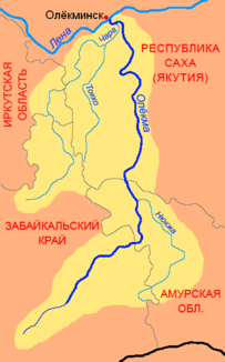
Location of the Nyuksha (Нюкжа) in the catchment area of the Oljokma |
||
The Nyuksha ( Russian Нюкжа ) is a right tributary of the Oljokma in the Transbaikalia region and in the Amur Oblast in the south of eastern Siberia .
The Nyukscha rises in the Nyukscha ridge ( Нюкжинский хребет ). It flows to the northeast at the beginning. At Larba it then turns to the northwest and flows along the southern flank of the western Stanowoy Mountains to its confluence at Ust-Nyukscha in the Oljokma. In the upper reaches the Nyuksha is rich in rapids. The Nyuksha is 583 km long. Its catchment area covers 32,100 km². The mean discharge (MQ) near the mouth is 310 m³ / s. The river is ice-covered between October and the end of April. The most important tributary of the Nyuksha is the Loptscha ( Лопча ) from the left.
