
Nordel (Diepenau)
|
Nordel
Spots Diepenau
Coordinates: 52 ° 27 ′ 0 ″ N , 8 ° 44 ′ 0 ″ E
|
|
|---|---|
| Height : | 70 m above sea level NHN |
| Incorporation : | March 1, 1974 |
| Postal code : | 31603 |
| Area code : | 05777 |
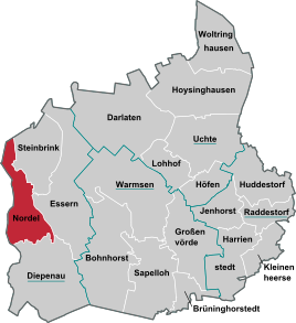

Nordel is a district of the borough Diepenau in the joint community lamp in Lower Saxony Nienburg / Weser in Germany .
Geographical location
Nordel is located in the southwest of the Nienburg / Weser district. The border with the state of North Rhine-Westphalia is one and a half kilometers to the west.
The Nordeler Bruch , six kilometers north of Nordel, is a 71 hectare nature reserve in the Diepenau area .
history
On March 1, 1974, Nordel was incorporated into Diepenau.
Infrastructure
- Nordel Chapel
The Essern-Steinbrink-Nordel parish is located in the Diepenau area.
Local public transport (ÖPNV)
Nordel is served by line 75 of the Verkehrsgesellschaft Landkreis Nienburg .
Road traffic
State road 343 runs two kilometers to the east from Wagenfeld to Diepenau.
Individual evidence
- ^ Federal Statistical Office (ed.): Historical municipality directory for the Federal Republic of Germany. Name, border and key number changes in municipalities, counties and administrative districts from May 27, 1970 to December 31, 1982 . W. Kohlhammer GmbH, Stuttgart / Mainz 1983, ISBN 3-17-003263-1 , p. 199 .
