Nordostrundingen
Coordinates: 81 ° 26 ′ 25 ″ N , 11 ° 29 ′ 22 ″ W.
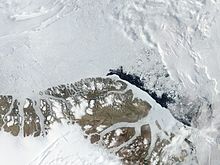
Nordostrundingen ( Danish correct Nordøstrundingen ) is the easternmost point of Greenland and at the same time the easternmost point of North America and the American double continent . It is located at the eastern end of the Prinsesse Dagmar Halvø peninsula , Kronprins Christians Land , in the almost deserted Northeast Greenland National Park , which does not belong to any municipality , 89 kilometers east of Station Nord , and in the extreme northeast of the former administrative district of Tunu (East Greenland). The point is further east than Iceland .
Small icebergs can often be seen on this coast, calving from the Flade Isblink glacier and running aground some distance from the coast. There are no large icebergs here, although there are numerous active glaciers.
Nordostrundingen separates the Greenland Sea in the south from the Wandelsee in the north. The sea route from the Atlantic to the Arctic Ocean is called the Fram Strait . On the eastern coast of the Greenland Sea opposite, about 435 km away, is Spitzbergen .
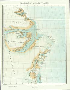
Nordostrundingen was first discovered and named by Europeans during the failed Danmark expedition led by Ludvig Mylius-Erichsen in August 1906 with a sledge . Until then, it was not known that Greenland extends that far to the east at this point. The expedition made a return depot there before splitting into two groups (one towards Independence Fjord , the other over sea ice towards Pearyland ).
The area was also toured by the Danish Alabama expedition in 1910, led by Ejnar Mikkelsen, in search of traces of Mylius-Erichsen, with records of the earlier expedition being found.
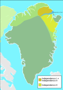
However, the site was already known to the Thule culture , as archaeological artifacts were found nearby, and probably also to the Independence I culture (found around 80 km to the west).
The area is covered by the Sirius patrol .

cards
Nordostrundingen is east of the area of the Independence cultures
See also
Web links
Individual evidence
- ^ National Geospatial-Intelligence Agency: Sailing Directions (enroute), Pub. 181: Greenland and Iceland, Bethesda 2010, Tenth Edition (PDF; 5.6 MB), p. 128
- ↑ Bjarne Grønnow, Jens Fog Jensen: The Northernmost Ruins of the Globe: Eigil Knuth's Archaeological Investigations in Peary Land and Adjacent Areas of High Arctic Greenland (= Monographs on Greenland . Volume 29 ). Museum Tusculanum Press, 2003, ISBN 87-635-1262-9 (English, limited preview in Google book search).
- ↑ Sirius starter of their forårstur. Slædepatruljen SIRIUS påbegynder the 20th of January of the Forårspatruljering af kystlandet along the north and north-east Greenland. (Norwegian; archived)


