
Normannstein spring
| Normannstein spring | ||
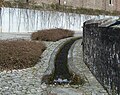
 Spring intake in Brunnenstrasse |
||
| Data | ||
| location | Thuringia , Germany | |
| Drain over | Werra → Weser → North Sea | |
| source | Normannstein Spring 51 ° 8 ′ 21 ″ N , 10 ° 14 ′ 15 ″ E |
|
| Source height | approx. 230 m above sea level NN | |
| muzzle | Treffurt coordinates: 51 ° 8 ′ 4 ″ N , 10 ° 14 ′ 9 ″ E 51 ° 8 ′ 4 ″ N , 10 ° 14 ′ 9 ″ E |
|
| Mouth height | approx. 173 m above sea level NN | |
| Height difference | approx. 57 m | |
| Bottom slope | approx. 71 ‰ | |
| length | 800 m | |
The Normannsteinquelle is a karst spring on the southern slope of the Normannstein and at the same time a natural monument . The Normannstein spring has a high and continuous bed . The water is clear and some of it is diverted to an elevated tank of the Treffurt municipal waterworks directly at the outlet, and from there it is used for the city's public drinking water supply.
location
The source is located in the old town of Treffurt , at the same time on the historic footpath to Normannstein Castle .
Blobach and Ziddelbach
The Normannstein spring is very important for the city's history. The suburban settlement was built along the Quellbach as early as the High Middle Ages . The source enabled the operation of eight mills, the brewing of beer in the town brewery, the tanner trade and the dye trade on the southern city wall. For this purpose, a system of brick, partially vaulted trenches and mostly open wooden gutters was created, which could reach large parts of the terraced old town. The two main canals are known as Blobach (eastern trench) and Ziddelbach (western trench). A street name still reminds of the Blobach today. The wooden channel from the Blobach, which was led across the market square on wooden supports, was still in use after the First World War and was considered a sight of the town. In the Topographia Hassiae by Matthäus Merian , under the chapter Drefurt (Treffurt) is noted:
- From this castle hill / first by the Ampts-Höfe / jumps out of a corridor carved deep into stone rock / a beautiful, bright / and strong fountain / which so soon / after its outflow / before it even descends / through the place / into the Werra fleust / (as far as a double heel shot may be anywhere) 14. Drives mills.
tourism
The Normannstein spring was and is a sight, some open sections of the restored water channel can be followed in the city area. A green area has been created around the source, where a lapidarium combines boundary stones and stone crosses from the Treffurt corridor.
gallery
At the Catholic Church

Blobach estuary into the Werra


literature
- Bernd Maisel: 10 years of urban renewal in Treffurt . Ed .: City administration Treffurt. Treffurt 2001, p. 11 .
- Willi Knabe, Helmut Grimm: Normannstein Spring . In: Stadtverwaltung Treffurt (Ed.): Treffurt. Walk through past and present . Printing and publishing house Frisch (Eisenach), Treffurt, p. 44-45 .
Individual evidence
- ↑ a b Topographic map 4928 1: 25,000
- ↑ Matthäus Merian: Topographia Hassiae (Hessen): Drefurt (on Wikisource )