Norsholmen

Norsholmen is a peninsula in Gotland Municipality and Gotland County , which is in the north of the Gotland neighboring island of Fårö .
The northern tip of the peninsula forms the northernmost point of Fårö. In the 18th century Norsholmen was still an island in its own right, which is reflected in today's name , which ends in " holm ". In Swedish, “en holm” means “an island” and “holmen” means “the island”. At that time this island was also called "Fenikkeholmen". The uplifting of the land meant that this island was transformed into a peninsula, which today separates the bays Tällevika and Ajkesvik.
nature
Norsholmen has been a bird sanctuary since 1967 and large parts of the peninsula are therefore not allowed to be entered from March 15th to July 15th. The bird sanctuary is 137.3 hectares and is also recognized as a Natura 2000 area. The area is best known as a place for resting and passing birds. In spring, large numbers of sea birds and waders ( Latin charadrii ) pass by here. Towards the end of May, large flocks of brent geese can be seen passing by on their way to their arctic breeding grounds. The breeding bird fauna consists of waders such as avocets , turnstone , ruff and dunlin, as well as terns such as arctic tern and little tern . At the turn of the month between July and August, schools of sandwich terns can be found on the peninsula.
Norsholmen is a flat peninsula with low vegetation, consisting of scattered juniper bushes and spacious dry and wet meadows. Sesleria uliginosa ( Swedish älväxing ), blue whistle grass , blue-green sedge and millet sedge grow on moist terrain . In the dry areas dominated Festuca ovina , Small meadowsweet , Breckland Thyme , Ulmåra , harebell , Cirsium acaule , Real kidney vetch , trefoil and gold thistle . The only occurrence of the rare common moon rue ( botrychium simplex in Latin ) is found on Norsholmen , on Gotland. Limestone beaches dominate along the headland, on which only Ruprecht's herb can grow.
Industrial ruins
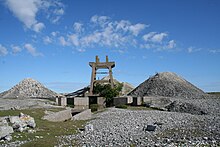
The most striking landmark on Norsholmen is an industrial ruin from the 1910s. During the First World War , a loading port for Gotland limestone was built here. The plant was shut down after only a few years of operation, probably because the lime was of insufficient quality. Today the concrete foundations and three large piles of stones remain on the southeast coast of the peninsula. The lime was transported to Norsholmen on a narrow-gauge railway, the embankment of which is now used as a hiking trail.
Archaeological sites
There are two grave fields on Norsholmen . At Västra riv , along the headland, there is a burial ground with seven loops and three round stone settings . In addition, there is another burial ground near Karriv on the eastern headland of the peninsula, which consists of 18 stone settings. In the middle of the peninsula is Kyrkogården , a medieval churchyard, which is surrounded by a curtain wall and has a diameter of about 35 m.
Maritime shipping
Several shipwrecks can be found off the coast of Norsholmen. The German cargo ship Fortuna , which sank in an autumn storm in 1969, clearly juts out of the water off the peninsula. At that time, the ship transported sodium hydroxide from Örnsköldsvik to Antwerp .
Far out on the tip of the peninsula is a small half-timbered lighthouse, Norsholmens fyr . Right next to it is on the country's Schifffahrtszeichen Norsholmens Stång .
Individual evidence
- ↑ a b Bevarandeplan for Natura 2000-område: Norsholmen SE0340096. (pdf; 227 kB) (No longer available online.) Länsstyrelsen i Gotlands län, archived from the original on December 5, 2015 ; Retrieved March 3, 2013 (Swedish). Info: The archive link was inserted automatically and has not yet been checked. Please check the original and archive link according to the instructions and then remove this notice.
- ↑ a b Norsholmen. (No longer available online.) Länsstyrelsen i Gotlands län, archived from the original on January 2, 2013 ; Retrieved March 3, 2013 (Swedish). Info: The archive link was inserted automatically and has not yet been checked. Please check the original and archive link according to the instructions and then remove this notice.
- ↑ Sesleria uliginosa Opiz. In: the virtuella floran. Retrieved March 3, 2013 (Swedish).
- ↑ Botrychium simplex E. Hitchc. In: the virtuella floran. Retrieved March 3, 2013 (Swedish).
- ↑ Fårö 162: 1 / Norsholmen - entry in the database "Fornsök" des Riksantikvarieämbetet (Swedish). Retrieved on 2013-03-03
- ↑ a b Norsholmen på Fårö. Gotland.net, accessed March 3, 2013 (Swedish).
- ↑ Västra riv - entry in the database "Fornsök" of the Swedish National Heritage Board (Swedish). Retrieved on 2013-03-03
- ↑ Karriv - entry in the database "Fornsök" des Riksantikvarieämbetet (Swedish). Retrieved on 2013-03-03
- ↑ Kyrkogården - entry in the database "Fornsök" des Riksantikvarieämbetet (Swedish). Retrieved on 2013-03-03
- ↑ Fortuna - entry in the database "Fornsök" des Riksantikvarieämbetet (Swedish). Retrieved on 2013-03-03
Coordinates: 57 ° 59 ′ 39.6 ″ N , 19 ° 13 ′ 45 ″ E


