Notom-Bullfrog-Road
The Notom-Bullfrog Road is a road in southern Utah , the parallel to Water Pocket Fold running, the Utah State Route 24 with State Route 276 connects.
description
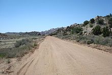
The Notom-Bullfrog-Road runs in a north-south direction through the valley of Sandy Creek and Halls Creek or Bullfrog Creek parallel to the Waterpocket Fold and connects the Capitol Reef National Park with the Glen Canyon National Recreation Area . The Wayne County northern section, which turns off Utah State Route 24 about nine miles east of the Capitol Reef National Park Visitor Center, is paved, and the central section, located in Garfield County , is unpaved. The road runs through the narrowing valley between the Waterpocket Fold and the Henry Mountains and crosses at the Bitter Creek Divide the pass that separates the valleys of Sandy Creek , which drains to the Fremont River, from Halls Creek, which flows in the direction of the Colorado River . After the road has crossed the Capitol Reef National Park border about 20 miles after exiting State Route 24, the Burr Trail goes west towards Boulder at km 55 . A few kilometers south, the road leaves the valley and runs over Thomson Mesa towards Bullfrog Canyon and Lake Powell . About five miles north of Bullfrog Marina , Notom-Bullfrog-Road joins Utah State Route 276.
The importance of the road results from its course along the Waterpocket Fold, so that its course is the starting point for numerous hiking trails, for example to several slot canyons . The Notom-Bullfrog-Road is of no importance for national traffic due to its impassability after rain and snowfall.
