
Nullarbor Plain


The Nullarbor Plain (ger .: Nullarbor Plain ), also called Nullarbor- desert called (from the Latin. Nulla arbor , not a tree ') is a flat, sprawling karst desert in southern Australia just off the Great Australian Bight . With around 200,000 square kilometers, it is the largest piece of limestone in the world. It measures over 1,200 km in an east-west direction.
Climate and vegetation
Due to the arid to semi-arid climate , the plain has a sparse flora , the vegetation consists mainly of small scrub. The plain is largely treeless, hence its name. The driest spot in Australia is in the Nullarbor Plain - even if it is usually assumed to be in the Northern Territory . In the city of Farina in South Australia , the annual rainfall is 142 mm, while in Alice Springs , which is also dry , there is an average of 281 mm of rain per year.
Much of the Nullarbor Plain is protected by the Nullarbor National Park.
The ocean to the south flows through subterranean caves in some places, which are located up to a few hundred meters inland and some come to the surface. One such area to visit is the Murrawijinie Caves in South Australia. Most of the other caves can only be visited with the permission of the conservation authorities.
traffic
The two ways to cross the Nullarbor Plain overland are the Indian-Pacific Railway from Sydney via Adelaide to Perth and the Eyre Highway from Norseman to Port Augusta . The flat landscape makes it the longest straight railway line in the world at 478 km. The railway runs straight through the plain, while the Eyre Highway only affects the southern parts. Part of the car route is the longest completely straight paved road in Australia at 146.6 km.
The group AC / DC , traveling in the tour bus, wrote the song Highway to Hell here .
Localities
Most of the inhabited areas of the Nullarbor Plain are found in small settlements near the railway line and in a small hotel complex called The Nullarbor on the Eyre Highway. The town of Cook in South Australia originally had 40 residents, with a school and even an 18-hole golf course, 1,365 km in size, making it the longest golf course in the world. The golf course starts in Kalgoorie and ends in Ceduna. The holes can be reached by car as they are up to 100 km apart. In order to play on all holes, you should plan up to 7 days. Due to the rationalization of the railway operations in the city of Cook and the resulting job losses, it was largely abandoned and today (2006) only has four (2 married couples) permanent residents.
Another formerly important settlement is Forrest . Before the jet age, Forrest was an important stopover for aircraft refueling en route through Australia. The runway including the lights (longest illuminated runway in Australia outside a capital city) is still kept ready for emergency landings. It is regularly used by small private planes for scheduled refueling (around three landings / take-offs per week). Two inhabitants still live in Forrest today, including the surrounding area, 18 inhabitants live in the administrative area of Forrest (as of 2006).
There is also an uninhabited place along the railway called Ooldea , which is used for water supply.
Picture gallery

Nullarbor Plain as seen from the Indian Pacific (2005)
Rainbow in the Nullarbor Plain (2005)

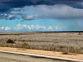
Eyre Highway in the Nullarbor Plain (2005)

Cave near the Eyre Highway

Indian Pacific of the Trans-Australian Railway in Cook (2009)

Trans-Australia steam train in the Nullarbor Plain (1924)


Web links
Individual evidence
Coordinates: 30 ° 46 ′ S , 128 ° 58 ′ E