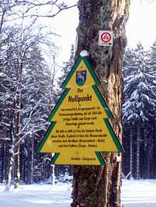
Zero point (resin)
The zero point in the Harz is 603.4 m above sea level. NHN is the highest point on today's state road 600, which leads in Lower Saxony as a connecting road from Braunlage to Zorge , and at the same time part of the watershed between northern ( Brunnenbach - Warme Bode - Bode ) and southern Harz ( Zorge - Helme - Unstrut ). It is located in the Upper Harz in the Harz Nature Park about 600 m northwest of the summit of the Hinterer Ebersberg (approx. 686 m ). This is where the surveying work on the new construction of the driveway began in 1864, which - apart from today's state road - is only used in sections as a forest path.
Coordinates: 51 ° 40 ′ 47.3 ″ N , 10 ° 37 ′ 7 ″ E
Individual evidence
- ↑ Map services of the Federal Agency for Nature Conservation ( information )
- ↑ Photo: The zero point on the Dennert-Tanne information board on de.wikipedia.org
