Olchinger See
| Olchinger See | ||
|---|---|---|

|
||
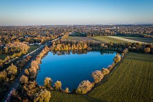
| Olchinger See from the air | ||
| Geographical location | Bavaria | |
| Tributaries | Zitzstaudengraben | |
| Drain | → New Ascherbach → Ampersee → Amper | |
| Data | ||
| Coordinates | 48 ° 12 '34 " N , 11 ° 21' 25" E | |
|
|
||
| Altitude above sea level | 500.5 m above sea level NN | |
| surface | 14.4 ha | |
| scope | 1.5 km | |
| Middle deep | 6 m | |

|
||
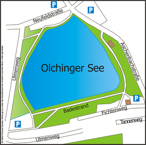
| Olchinger See map. | ||
The Olchinger See is a quarry pond in the area of the city of Olching , directly on the border with the community of Gröbenzell , almost 20 km west of Munich .
description
The lake was created in 1940 by gravel mining by the German Reichsbahn . It lies in the conservation area Graßl finger moss and Olchinger lake , which is about ha 590th For this reason it has ecological compensation areas on the south bank. The Münchner Erholungsflächenverein e. In 1969 V. arranged for the establishment of the Olchinger See recreation area (25.3 ha). In addition to a circular hike, there are 5.3 hectares of sunbathing lawn for bathers, installations for the handicapped (entry aid into the lake, changing room) and a water watch. A restaurant with a beer garden, a kiosk and a mini golf course on the north side of the lake are also part of the recreational facilities on the lake. The lake is now also popular with those looking for relaxation from the wider area. The city of Olching is now solely responsible for maintaining Lake Olching, after the Fürstenfeldbruck district ceased its support services in 2006. From April 2006 to early July 2006, the lake was an observation area for the H5N1 bird flu .
In addition to the Olchinger See , north of the Munich-Stuttgart motorway ( BAB 8 ), there is a second bathing lake, the Ampersee , in the area of the city of Olching.
Small Olchinger See

The Kleine Olchinger See is about 10 minutes' walk from the Olchinger See . It is located south of the main railway line from Munich to Augsburg and can only be reached on foot or by bike. Since it is located on the border between Gröbenzell and Olching, it is often referred to as the Gröbenzeller See by the residents . It is not managed and has no water station. The path around the lake is not paved and is partly on private land. At the eastern end there are some built-up plots with sea access.
See also
Web links
- Münchner Erholungsflächenverein e. V. to the recreation area Olchinger See
- Health department of the district of Fürstenfeldbruck on the water quality of the lake
- Statistical information from the Fürstenfeldbruck district on the lake


