Oldoi
|
Oldoi Ольдой, Большой Ольдой (Bolshoi Oldoi) |
||
|
|
||
| Data | ||
| Water code | RU : 20030300112118100020034 | |
| location | Amur Oblast ( Russia ) | |
| River system | Amur | |
| Drain over | Amur → Tatar Sound | |
| source |
Chernyshova mountain range 54 ° 59 ′ 46 ″ N , 123 ° 21 ′ 24 ″ E |
|
| Source height | approx. 700 m | |
| muzzle |
Amur coordinates: 53 ° 33 '17 " N , 123 ° 19' 46" E 53 ° 33 '17 " N , 123 ° 19' 46" E |
|
| Mouth height | 283 m | |
| Height difference | approx. 417 m | |
| Bottom slope | approx. 1.5 ‰ | |
| length | 287 km | |
| Catchment area | 9970 km² | |
| Left tributaries | Maly Oldoi | |
| Right tributaries | Chaikta | |
| Communities | Madalan | |
|
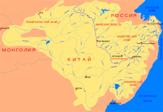
Location of the Oldoi (Ольдой) in the catchment area of the Amur |
||
The Oldoi ( Russian Ольдой; Большой Ольдой (Bolshoi Oldoi, "Great Oldoi")) is a left tributary of the Amur in the Amur Oblast in the Far East of Russia .
The Oldoi rises in the Chernyschowa mountain range . From there it flows mainly in a southerly direction to the Amur. It flows through the administrative districts of Tynda and Skoworodino . The Oldoi has a length of 287 km. It drains an area of 9970 km². Larger tributaries of the Oldoi are Maly Oldoi (left) and Chaikta (right).
Individual evidence
- ↑ a b Oldoi in the State Water Register of the Russian Federation (Russian)
