Ospika River
| Ospika River | ||
|
|
||
| Data | ||
| location | British Columbia (Canada) | |
| River system | Mackenzie River | |
| Drain over | Peace River → Slave River → Mackenzie River → Arctic Ocean | |
| Headwaters |
Muskwa Ranges 57 ° 14 ′ 44 ″ N , 124 ° 25 ′ 47 ″ W. |
|
| Source height | approx. 1600 m | |
| muzzle |
Williston Lake Coordinates: 56 ° 19 ′ 11 " N , 123 ° 57 ′ 25" W 56 ° 19 ′ 11 " N , 123 ° 57 ′ 25" W. |
|
| Mouth height | approx. 660 m | |
| Height difference | approx. 940 m | |
| Bottom slope | approx. 7.2 ‰ | |
| length | approx. 130 km | |
| Catchment area | approx. 3070 km² | |
| Discharge at the gauge above Aley Creek A Eo : 2190 km² Location: 27 km above the mouth |
MQ 1981/2015 Mq 1981/2015 |
40.1 m³ / s 18.3 l / (s km²) |
| Left tributaries | McCusker Creek | |
|
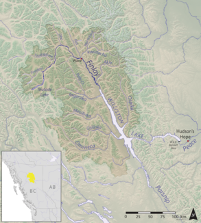
Location of the Ospika River |
||
The Ospika River is a tributary of the Williston Lake reservoir in the Canadian province of British Columbia .
The Ospika River rises in the Muskwa Ranges , the northernmost section of the Rocky Mountains . It flows in a predominantly south-southeast direction through the mountains and finally flows into the Ospika Arm , the mouth of the river at the lower section of Finlay Reach , the north arm of Williston Lake. Before the Peace River was dammed, the Ospika River flowed into its source river, the Finlay River . The length of the Ospika River is about 130 km. At the gauge above Aley Creek , the mean discharge of the Ospika River is 40.1 m³ / s. The catchment area covers around 3070 km². The most important tributary is McCusker Creek from the left.
