Pöbelbach
| Pöbelbach | ||
|
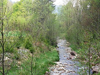
The Pöbelbach near Oberpöbel |
||
| Data | ||
| location | District of Saxon Switzerland-Eastern Ore Mountains , Saxony , Germany | |
| River system | Elbe | |
| Drain over | Rote Weißeritz → Weißeritz → Elbe → North Sea | |
| source | in the municipality of Hermsdorf / Erzgeb. | |
| muzzle | in Schmiedeberg in the Rote Weißeritz Coordinates: 50 ° 50 '12 " N , 13 ° 40' 33" E 50 ° 50 '12 " N , 13 ° 40' 33" E
|
|
| Discharge at the Bärenfels A Eo gauge : 6.21 km² Location: 5.5 km above the mouth |
NNQ (11/15/1965) MNQ 1966-2014 MQ 1966-2014 Mq 1966-2014 MHQ 1966-2014 HHQ (12.08.2002) |
0 l / s 8 l / s 143 l / s 23 l / (s km²) 2.29 m³ / s 20 m³ / s |
The Pöbelbach is a tributary of the Roten Weißeritz in the Saxon Eastern Ore Mountains .
course
Its sources are in the municipality of Hermsdorf / Erzgeb. , then it forms the Pöbeltal, in which the Pöbeltalbahn was to be set up at the beginning of the 20th century . The Pöbelbach is eponymous for the districts Oberpöbel and Niederpöbel of Dippoldiswalde . In Schmiedeberg the water flows into the Rote Weißeritz from the left.
A flood protection dam is currently being built above Niederpöbel.
Former mills in the Pöbelbachtal were the cleaning mill and the layer mill in Oberpöbel.
See also
Individual evidence
- ^ German Hydrological Yearbook Elbe Region, Part I 2014. (PDF) State Office for Flood Protection and Water Management Saxony-Anhalt, p. 113 , accessed on November 3, 2018 (from: lhw.sachsen-anhalt.de).
- ↑ A kind of construction diary

