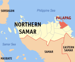
Palapag
| Municipality of Palapag | ||
| Location of Palapag in the Northern Samar Province | ||
|---|---|---|

|
||
| Basic data | ||
| Region : | Eastern Visayas | |
| Province : | Northern Samar | |
| Barangays : | 32 | |
| District: | 2. District of Northern Samar | |
| PSGC : | 084814000 | |
| Income class : | unknown (1-6) | |
| Households : | 5852 May 1, 2000 census
|
|
| Population : | 34,286 August 1, 2015 census
|
|
| Coordinates : | 12 ° 33 ' N , 125 ° 7' E | |
| Postal code : | 6421 | |
| Mayor : | Ricardo M. Daiz | |
| Geographical location in the Philippines | ||
|
|
||
Palapag is a Filipino municipality in the Northern Samar Province . It has 34,286 inhabitants (August 1, 2015 census).
Barangays
Palapag is politically divided into 32 barangays .
|
|
|
history
Palapag was the hometown of Juan Ponce Sumuroy , who led a rebellion against the Spanish colonial rulers from 1649 to 1650. Juan Ponce Sumuroy belonged to the Waray people . The main reason for the so-called Sumuroy Rebellion was the forcible recruitment of workers from Eastern Visayas to work in the shipyards in Cavite .
Web links
- elgu.ncc.gov.ph - Palapag ( Memento from November 20, 2007 in the Internet Archive )
