Lavezares
| Municipality of Lavezares | ||
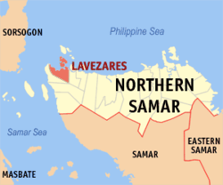
| Location of Lavezares in the Northern Samar Province | ||
|---|---|---|

|
||
| Basic data | ||
| Region : | Eastern Visayas | |
| Province : | Northern Samar | |
| Barangays : | 26th | |
| District: | 1. District of Northern Samar | |
| PSGC : | 084811000 | |
| Income class : | 4. Income bracket | |
| Households : | 4637 May 1, 2000 census
|
|
| Population : | 28,770 August 1, 2015 census
|
|
| Coordinates : | 12 ° 32 ' N , 124 ° 20' E | |
| Postal code : | 6404 | |
| Mayor : | Quintin B. Saludaga | |
| Geographical location in the Philippines | ||
|
|
||
Lavezares is a Filipino municipality in the Northern Samar Province .
The community is characterized by its location on the Pacific, near the San Bernardino Strait , through which shipping to the islands of the Visayas receives. There is a transport connection to Manila by ferry from the neighboring port of Allen to Matnog on the Sorsogon peninsula . From Lavezares there are daily boats to the offshore Balicuatro Islands, which are located in the land and marine reserve Biri Larosa Protected Landscape / Seascape , with the main island Biri Island . In the vicinity of Lavezares there are some charming bays and beaches, but there is no tourist marketing yet.
Barangays
Lavezares is politically divided into 26 barangays .
|
|
