Matnog
| Municipality of Matnog | ||
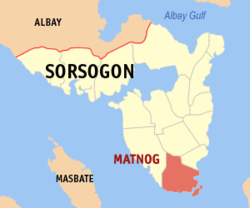
| Location of Matnog in the province of Sorsogon | ||
|---|---|---|

|
||
| Basic data | ||
| Region : | Bicol region | |
| Province : | Sorsogon | |
| Barangays : | 40 | |
| District: | 2. District of Sorsogon | |
| PSGC : | 056212000 | |
| Income class : | 3rd income bracket | |
| Households : |
May 1, 2000 census
|
|
| Population : | 41,101 August 1, 2015 census
|
|
| Population density : | 253.1 inhabitants per km² | |
| Area : | 162.40 km² | |
| Coordinates : | 12 ° 35 ' N , 124 ° 5' E | |
| Postal code : | 4708 | |
| Geographical location in the Philippines | ||
|
|
||
Matnog is a Filipino municipality in the province of Sorsogon . It has 41,101 inhabitants (August 1, 2015 census) who lived in 40 barangays . Matnog belongs to the third income bracket of the communities in the Philippines. It is located about 48 km south of the provincial capital Sorsogon City on San Bernardino Street . Their neighboring communities are Bulan in the northwest, Irosin in the north and Santa Magdalena in the northeast.
Matnog is an important ferry port for traffic to the neighboring island of Samar and on the Maharlika Highway .
Barangays
|
|
|
