Donsol
| Municipality of Donsol | ||
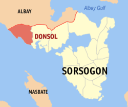
| Location of Donsol in the province of Sorsogon | ||
|---|---|---|

|
||
| Basic data | ||
| Region : | Bicol region | |
| Province : | Sorsogon | |
| Barangays : | 51 | |
| District: | 1. District of Sorsogon | |
| PSGC : | 056207000 | |
| Income class : | 3rd income bracket | |
| Households : |
May 1, 2000 census
|
|
| Population : | 49,711 August 1, 2015 census
|
|
| Population density : | 318.3 inhabitants per km² | |
| Area : | 156.20 km² | |
| Coordinates : | 12 ° 54 ' N , 123 ° 36' E | |
| Postal code : | 4715 | |
| Geographical location in the Philippines | ||
|
|
||
Donsol is a Filipino municipality in the province of Sorsogon in the southeastern part of the island of Luzon. It has 49,711 inhabitants (August 1, 2015 census) who lived in 51 barangays . Donsol belongs to the third income bracket of the communities in the Philippines. The community is located approx. 45 km southwest of the provincial capital Sorsogon City at the entrance of the Burias Canal. Their neighboring parishes are Pilar in the east and the parishes in the province of Albay in the north and northwest.
Barangays
|
|
|
