Palisades (Sierra Nevada)
| Palisades | ||
|---|---|---|
|
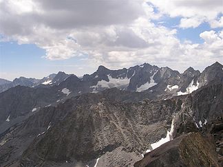
North flank of the Palisades |
||
| Highest peak | North Palisade ( 4341 m ) | |
| location | California (USA) | |
| part of | Sierra Nevada | |
|
|
||
| Coordinates | 37 ° 6 ′ N , 118 ° 31 ′ W | |
The Palisades (also Palisade Range ) are an unofficial, but collective term used in mountaineering circles for a group of mountains on the eastern flank of the southern Sierra Nevada in the US state of California . The group includes four peaks over 14,000 feet (4,267 m), making up more than a third of all Fourteeners in California.
Geographical location
The mountain range lies west of the town of Big Pine above the Owens Valley , and stretches from northwest to southeast for about 18 km. In the north, separated by the Bishop Pass , is the Inconsolable Range . The southern limit is the Taboose Pass .
On the northeast side are the two largest glaciers of the Sierra Nevada, which are also the southernmost in North America. The meltwater from these glaciers flows east into Big Pine Creek, which flows into the Owens River . To the west of the mountains are the Palisade Lakes, which drain over Palisade Creek to the Kings River . The ridge of the mountains forms the border between Sequoia & Kings Canyon National Park in the west and the John Muir Wilderness in the east, a strict nature reserve of the Wilderness Area type . On the west side of the leading long-distance hiking the Pacific Crest Trail below the group along and opens up access.
glacier
There are several glaciers on the northeast flank along the mountain range. The Palisade Glacier and Middle Palisade Glacier are considered to be the longest glaciers in the Sierra Nevada. The Palisade Glacier is the southernmost glacier in the United States and the larger of the two.
The Palisade Glacier was formed around 700 years ago during the Little Ice Age . It is 0.8 km² in size, 1.2 km long and 0.8 km wide and lies at an altitude of approx. 3658 m to 4084 m. Like many others around the world, the glacier is severely affected by global warming. It retreats by around 7 m in one year. The Palisade Glacier is one of the few whose meltwater is dammed into a lake, limited by the glacier's moraine . The resulting lake appears turquoise due to the glacier snow floating in the water. The Big Pine lake below the glacier has the same color. Other special features of the glacier are some smaller crevasses and a glacier mill , which was formed during a drought in 1977.
The Norman Clyde Glacier is one of the smaller glaciers in the Sierra Nevada. It is right on Norman Clyde Peak. A mountain ridge separates the glacier from the larger, neighboring Middle Palisade Glacier.
Summit of the Palisades
| Surname | height | Special | Geographical location |
|---|---|---|---|
| North Palisade | 4341 m | Highest mountain in the Palisades | 37 ° 5 '38.35 "N, 118 ° 30' 52.59" W. |
| Mount Sill | 4317 m | 37 ° 5 '45.00 "N, 118 ° 30' 13.55" W. | |
| Split Mountain "South Palisade" | 4287 m | 37 ° 1 '11.65 "N, 118 ° 25' 20.11" W. | |
| Middle palisade | 4279 m | 37 ° 4 '11.48 "N, 118 ° 28' 9.15" W. | |
| Mount Agassiz | 4236 m | northwestern peak | 37 ° 6 '41.23 "N, 118 ° 31' 51.24" W. |
| Norman Clyde Peak | 4223 m | 37 ° 4 '27.45 "N, 118 ° 28' 28.75" W. | |
| Mount Winchell | 4196 m | 37 ° 6 '16.33 "N, 118 ° 31' 35.75" W. | |
| Birch Mountain | 4165 m | 37 ° 3 '43.94 "N, 118 ° 25' 9.25" W. | |
| Temple Crag ( Temple Crag ) | 3962 m | Popular climbing spot in the Palisades | 37 ° 6 '37.01 "N, 118 ° 29' 27.16" W. |
North Palisade
The North Palisade (German: "North Palisade") forms the highest peak of the Palisades, and at the same time the third highest of the Sierra Nevada. The characteristic of the mountain is the fact that it consists of several peaks. In addition to the main peak, it has three other peaks:
- Polemonium Peak , 4292 m; Prominence: 44-73 m
- Starlight Peak (" Starlight Peak "), 4292 m; Prominence: 24-49 m
- Thunderbolt Peak ("Blitzspitze"), 4268 m; Prominence: 68 m
These three peaks are part of the North Palisade massif and are subordinate to the main summit. They are not considered to be mountains in their own right, as their prominence is too low.
The North Palisade was first climbed on July 25, 1903 by James S. Hutchinson, Joseph N. LeConte and JK Moffitt.
Mount Sill
Mount Sill is 600 m from the North Palisade, which is connected to the mountain by a ridge, and is located directly south of the Palisade Glacier. The mountain was first climbed in 1903 by James S. Hutchinson, Joseph N. LeConte, James Moffitt and Robert Pike. Joseph LeConte named it after the poet Edward Rowland Sill. There are routes to the summit from all directions , climbing experience is required.
Split Mountain
The Split Mountain (German: "Geilter Berg") or "South Palisade" (German: "Südpalisade") is located near the southeast end of the Palisades. The mountain forms the eighth highest peak in California. The name comes from its striking double point. The mountain is considered to be one of the easier four-thousanders in California and was first climbed in 1807 by a group of climbers led by Frank Saulque. The mountain consists mainly of granite ; the two-tone appearance of the eastern flank is due to the dark-colored granodiorite and the light-colored leucogranite.
Middle palisade
The Middle Palisade (German: "Mittel-Palisade") lies roughly in the center of the Palisades. The Middle Palisade is the twelfth highest peak in California . There are routes of varying difficulty to the summit from different sides of the mountain. The easiest route is over the eastern flank.
Mount Agassiz
Mount Agassiz was named by Lilbourne Winchell after Harvard professor Louis Agassiz . The United States Geological Survey later recognized this name as official. Mount Agassiz forms the northeastern part of the Palisades. There are routes to the summit from the west and south, but they are not clearly recognizable. You can quickly get off the route and get into areas where you shouldn't continue climbing without a rope .
Norman Clyde Peak
The Norman Clyde Peak probably got its name from the first to climb (1930) Norman Clyde. North of the mountain is the Norman Clyde Glacier and east of the Middle Palisade Glacier. The mountain lies between the Middle Palisade and the Palisade Crest (German: "Palisade crest").
Mount Winchell
Mount Winchell was named after the geologist Alexander Winchell and is one of the highest peaks in California. The mountain lies south of Mount Agassiz and is in the northern part of the Palisades.


