Pancíř
| Pancíř | ||
|---|---|---|
|
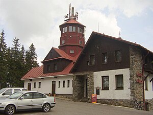
Pancíř peak with a lookout tower |
||
| height | 1214 m nm | |
| location | Czech Republic | |
| Mountains | Bohemian forest | |
| Coordinates | 49 ° 10 '44 " N , 13 ° 15' 14" E | |
|
|
||
The Pancíř (German Panzer ) is a 1214 m high mountain in the northern part of the Bohemian Forest in the Czech Republic . It is located six kilometers north of the town of Železná Ruda near the village of Špičák .
On the summit there is a hut with a 23 m high observation tower. A chair lift goes from Špičák to the Pancíř.
The European main watershed between the Elbe and the Danube runs over the Pancíř . The source of the Úhlava is located on the western slope , the Slatinný potok rises on the eastern slope and the Great Rain rises on the southern slope . To the north, on the ridge of the Pancíř, the peaks Habr (1203 m) and Můstek (1234 m), where the Křemelná originates , join .
From the viewing platform at a height of 18 m there is a good view of the Zwercheck and the Jezerní hora (High Sea Wall) with the Jezerní stěna (Sea Wall) rock face and the coffins of the Čertovo jezero (Devil's Lake) and Černé jezero (Black Lake) as well as parts of the Bohemian Forest, with a clear view as far as the Alps.
The hut and the tower were built in 1923. In 1971 a chairlift was put into operation between Špičák and Pancíř. It has a length of 2.739 km. Halfway below the summit there is a stopover at Hofmanky.

